Catalog Archive
Auction 189, Lot 359

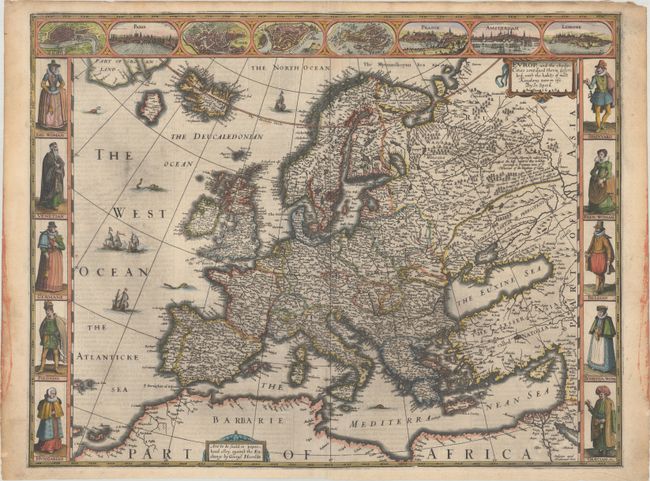
Speed's Carte-a-Figures Map of Modern Europe

"Europ, and the Cheife Cities Contayned Therin Described; with the Habits of Most Kingdoms Now in Use", Speed, John

Subject: Europe

Period: 1626 (dated)

Publication: A Prospect of the Most Famous Parts of the World

Color: Hand Color

Size:
20 x 15.4 inches
50.8 x 39.1 cm
Download High Resolution Image
(or just click on image to launch the Zoom viewer)

This is one of the most beautiful carte-a-figure maps of Europe, surrounded with vignettes on three sides. The upper frieze has eight bird's-eye views of London, Paris, Rome, Constantinople, Venice, Prague, Amsterdam and Lisbon. The side borders contain the costumes of the noblemen and women of ten European nations. The map shows the well-detailed but fictitious island of Frisland just off the coast of Iceland, and the seas are alive with sea monsters and ships. Beautifully engraved by Abraham Goos and published by George Humble between 1627-32. Related English text on verso.

References: Shirley (BL Atlases) T.SPE-2a #4.

Condition: A

A sharp impression on paper with a bunch of grapes watermark. There are a few tiny wormholes in the bottom corners only visible when held to light and minor soiling in the margins. Remnants of hinge tape on verso.

Estimate: $3,000 - $3,750

Sold for: $2,200

Closed on 9/14/2022

Archived