Catalog Archive
Auction 189, Lot 287

Scarce Sea Chart with Interesting Depiction of the Coastline of the US

"Pascaerte van Westindien de Vaste Kusten en de Eylanden", Goos, Pieter

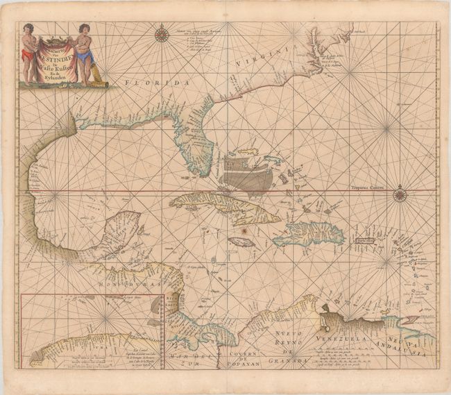
Subject: Gulf of Mexico & Caribbean

Period: 1666 (circa)

Publication: De Zee-Atlas, ofte Water-Weereld

Color: Hand Color

Size:
21.5 x 17.6 inches
54.6 x 44.7 cm
Download High Resolution Image
(or just click on image to launch the Zoom viewer)

Goos' scarce map of the Gulf of Mexico and Caribbean was based on Hessel Gerritsz' map of the region published circa 1631, which influenced numerous derivatives. Goos included updates from other derivatives, including the cartography of the Gulf of Mexico as depicted by Joannes van Loon, circa 1661, and the mildly sloped coastline of the Southeast U.S. as depicted by Hendrick Doncker, circa 1659. However Goos' map was the first derivative to include Gerritsz' inset of the northern coast of Cuba, which fills the bottom left corner. Goos also made some improvements, such as the depiction of the Outer Banks. The map is adorned with two compass roses and the title appears on a cow hide held aloft by two cherubs.

References: Burden #389.

Condition: B+

A nice impression with light toning, a few spots of foxing, and a small paper flaw near the center of the map. There are archivally repaired centerfold separations at top and bottom.

Estimate: $2,000 - $2,300

Sold for: $1,500

Closed on 9/14/2022

Archived