Catalog Archive
Auction 189, Lot 161

One of the Most Important 17th Century Maps of the Chesapeake Bay

"Nova Virginiae Tabula", Hondius, Henricus

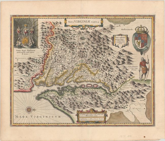
Subject: Colonial Mid-Atlantic United States

Period: 1633 (published)

Publication: Gerardi Mercatoris - Atlas sive Cosmographicae

Color: Hand Color

Size:
19.6 x 15.1 inches
49.8 x 38.4 cm
Download High Resolution Image
(or just click on image to launch the Zoom viewer)

This graphic map is Henricus Hondius' version of Capt. John Smith's important map of 1612, drawn from his brother's map of 1618. After the death of Jodocus Hondius in 1629, his widow sold a number of plates to Blaeu. Angry at the sale to a competitor, Henricus and Joannes Jansson engaged engravers to cut new plates, which were largely based on Jodocus' work. This is the 5th derivative of Smith's map. It is beautifully engraved with topographical features and the locations of scores of Indian villages. In the upper left corner is an engraving of the great Indian chief Powhatan seated on his throne and surrounded by his subjects. A Susquehanna chief, facing in toward Chesapeake Bay (opposite of Jodocus' plate), is depicted on the right under a coat of arms. French text on verso.

References: Burden #228; Tooley (Amer) pp. 165-66; Van der Krogt (Vol. I) #9410:1.

Condition: A

A sharp impression on a bright, watermarked sheet with a small paper flaw and two small worm holes in the bottom blank margin.

Estimate: $2,000 - $2,300

Sold for: $1,500

Closed on 9/14/2022

Archived