Catalog Archive
Auction 189, Lot 157

Jefferys' Influential Map of New England in Contemporary Outline Color

"[On 2 Joined Sheets] A Map of the Most Inhabited Part of New England, Containing the Provinces of Massachusets Bay and New Hampshire, with the Colonies of Conecticut and Rhode Island...", Jefferys, Thomas

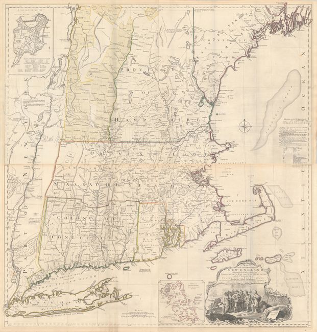
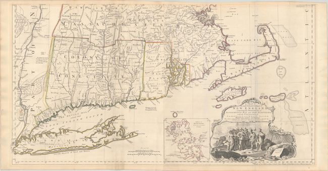
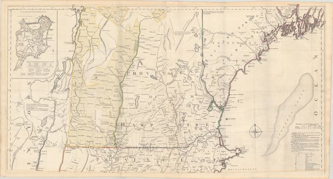
Subject: Colonial New England United States

Period: 1774 (dated)

Publication:

Color: Hand Color

Size:
38.8 x 20.5 inches
98.6 x 52.1 cm
Download High Resolution Image
(or just click on image to launch the Zoom viewer)

Thomas Jefferys was one of the most important English map publishers of the 18th century. His work included prints and maps of locations around the world, but his most notable maps are of North America and the West Indies. He began his career in the map trade in the early 1730s, working as an engraver for a variety of London publishers, and eventually setting up his own shop. In 1746, he was appointed Geographer to the Prince of Wales, and in 1760 he became Geographer to the King. These titles granted access to manuscripts and cartographic information held by the government. In the early 1760s he embarked on an ambitious project to produce a series of English county maps based on new surveys, but ran out of money and filed for bankruptcy in 1766. He then partnered with London publisher Robert Sayer, who reissued many of Jefferys plates and continued to issue new editions after Jefferys' death in 1771. Jefferys' American Atlas and the accompanying West-India Atlas, published post posthumously, are considered his most important cartographic works.

This is the fifth state of Jefferys' celebrated map of New England. The map was first issued in 1755 at the beginning of the French and Indian War, and it became the most influential map of the region for the next several decades. The map was compiled by Bradock Mead (alias John Green) from influential contemporary sources, primarily Plan of the British Dominions of New England in North America (1753) by Dr. William Douglass. Credit is given to each of the surveys used in a table at right on the northeast sheet, although Douglass' map is strangely omitted from the list. Jefferys' map represents the first widely disseminated, large-format depiction of the region and is a significant improvement over the Douglass map, in part because of the additional territory covered and almost certainly the additional information which was likely available to Jefferys and Mead in the several years following the issue of the Douglass map.

The map covers the area from Penobscot Bay to the Hudson River. It shows villages, towns, roads, counties, watershed, mountains and topography, and information along the coast, including islands, bays, and much more. A title cartouche at bottom right incorporates an idealized vignette of the Pilgrims arriving at Plymouth, greeted by a Native American with a liberty cap. Stevens & Tree identify this as the third edition (or fifth state), virtually identical to the preceding state with the exception of the imprint, now dated November 29th, 1774. The map was significantly updated circa 1763 with a new inset and geographical changes. Most notably, the area in present-day Vermont and New Hampshire that was previously labeled Wildernes Lands of the Crown not yet appropriated has been revised into a grid of townships. The region's lakes have also been rendered with greater accuracy. A note at top left refers to the Connecticut River as the New York-New Hampshire boundary and that the townships in yellow are part of New Hampshire. There are two insets: "A Plan of Boston Harbor" (bottom right) and "A Plan of the Town of Boston" (top left). The latter inset was a replacement for the plan of Fort Frederick that appeared on the first two states of the map. This example is joined in two long, horizontal sheets, joining the two northern and the two southern sheets. If fully joined, the map would measure approximately 38.8 x 41.0".

References: McCorkle #755.19; Pritchard & Taliaferro #35; Stevens & Tree (MCC-39) #33(e).

Condition: B+

Crisp impressions with contemporary outline color on sturdy, watermarked paper. There are a few faint spots, light printer's ink residue, and minor toning mostly along the map borders. The first image is a composite image - the maps are joined in two horizontal sheets, as described.

Estimate: $5,000 - $6,500

Sold for: $3,750

Closed on 9/14/2022

Archived