Catalog Archive
Auction 188, Lot 72

One of the Earliest Maps Devoted to North America

"Novi Orbis Pars Borealis, America Scilicet, Complectens Floridam, Baccalaon, Canadam, Terram Corterialem...", Quad, Matthias von Kinckelbach

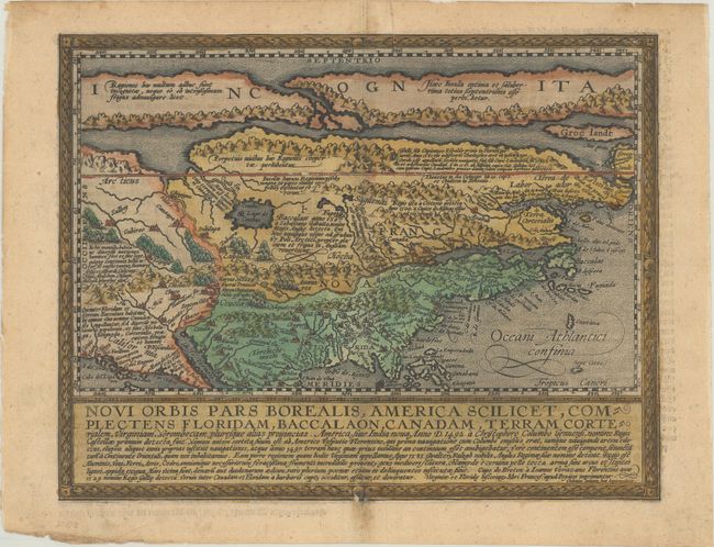
Subject: Colonial North America

Period: 1600 (circa)

Publication:

Color: Hand Color

Size:
11.6 x 8.9 inches
29.5 x 22.6 cm
Download High Resolution Image
(or just click on image to launch the Zoom viewer)

Very unusual map based on Cornelis de Jode's Americae Pars Borealis. It makes use of both John White and Jacques le Moyne's east coast cartography, but continues de Jode's inaccurate depiction of Virginia. Charlesfort is shown on the r. de Gallo with St. Helena just to the south. In the north is a Northwest Passage, and in the center is the Lago de Conibas. To the west of Florida is a curious second peninsula named Apalaco. The map is fully engraved with mountains, forests and cities with numerous notations throughout. Below the map is a panel of Latin text describing the various explorations. Engraved by Johannes Bussemacher. German text on verso.

References: Burden #133; Cumming #24.

Condition: B+

A nice impression with very light toning along the centerfold, marginal soiling, and two small abrasions along the neatline at bottom center.

Estimate: $3,000 - $3,750

Sold for: $2,200

Closed on 6/22/2022

Archived