Catalog Archive
Auction 188, Lot 63

Features a Large Island of California

"L'Amerique Selon les Nouvelles Observations de Messrs. de l'Academie des Sciences, Etc.", Aa, Pieter van der

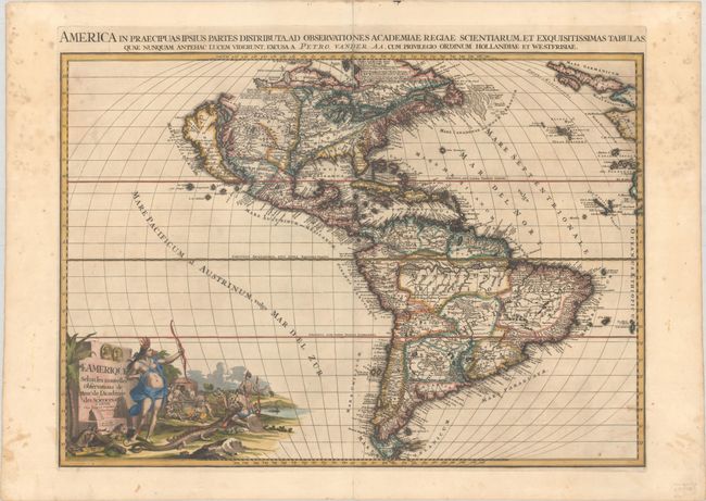
Subject: Western Hemisphere - America

Period: 1713 (circa)

Publication: Le Nouveau Theatre du Monde...

Color: Hand Color

Size:
26.3 x 18.6 inches
66.8 x 47.2 cm
Download High Resolution Image
(or just click on image to launch the Zoom viewer)

A highly decorative and detailed map of the Americas with the island of California prominently depicted with a heavily indented northern coastline on the second Sanson model. The British colonies are confined to the Eastern seaboard by Les Cinq Nationals Iroquoises while the French possessions extend to the Mississippi River, which is placed too far to the west. The Spanish possession of Florida includes the Carolinas, Florida and the Gulf of Mexico coastal regions. Nova Mexicana and Nova Granada take in all of the west coast. In South America, the coastline bulges too far to the east, and the Orinoco is confused with the River Negro. Despite using some outdated cartographic concepts (Carl Wheat calls this a "throwback" map), it is filled with details and notations. A superb pictorial title cartouche features a legendary Amazon with her bow held high and a cannibalistic feast in the background. Drawn by J. Goeree and engraved by J. Baptist with imprint in the title cartouche. A Latin title is outside the top border, " America in Praecipuas Ipsius Partes Distributa ad Observationes..."

References: McLaughlin #184; Tooley (America) #71, p.129; Wheat #95.

Condition: B+

On watermarked paper with a centerfold separation that extends 1.75" into the image at top and has been archivally repaired on verso. There is some light staining that is more prevalent in the upper side margins.

Estimate: $2,750 - $3,500

Sold for: $1,800

Closed on 6/22/2022

Archived