Catalog Archive
Auction 188, Lot 57

Extremely Rare Map with Four Paneled Borders

"America Noviter Delineata", Hondius, Jodocus

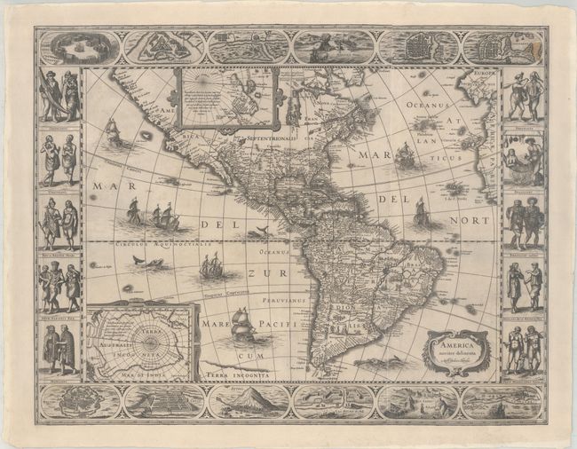
Subject: Western Hemisphere - America

Period: 1618 (published)

Publication:

Color: Black & White

Size:
24.1 x 18.8 inches
61.2 x 47.8 cm
Download High Resolution Image
(or just click on image to launch the Zoom viewer)

This extremely rare, magnificent map of the Americas is the first state of Jodocus Hondius' map, prior to the removal of the carte-a-figures borders. Hondius derived the cartography from two earlier maps by Blaeu - his 1608 and 1617 maps of the Americas. Although Blaeu's 1608 and 1617 maps featured borders on 3 sides (the 1608 omitted a top border and the 1617 omitted a bottom border) Hondius elected to incorporate extravagant borders on all four sides of his map. At top and bottom are twelve views of important cities such as St. Augustine, Havana, Cartagena, Mexico City, Cusco and Rio de Janeiro. Along the sides are 10 portraits of Native Americans from various regions, shown in male-female pairs, occasionally with a child. The regions represented include Virginia, Florida, Mexico, Greenland, Peru, Brazil and Chile. The borders were copied from Blaeu's maps with the portraits most closely resembling the 1617 map (although in reverse, matching the orientation of the figures on the 1608 map), with the exception of the Greenland figures, for which the left-hand figure matches the 1608 map, but the right-hand figure appears to be from another source.

Cartographically the map also draws from Blaeu. North America retains the peninsular California and the East Coast is beginning to take shape, although it still lacks detail in the mid-Atlantic region. In the Southwest, the famous seven cities of Cibola appear on the banks of a large lake. In South America, there is a large inland sea on the equator (the mythical Parime Lacus) and two engraved scenes - one detailing a cannibalistic feast. Hondius also includes new information from Jacob le Maire and Willem Schouten's voyage around Cape Horn, depicting Tierra del Fuego as separate from Terra Incognita - the great southern continent. (Blaeu also made this change on later states of his 1608 and 1617 maps.) However Hondius' updates are not quite accurate, as he switches Staten Eylant and I. Mauritius and neglects to add several islands discovered by le Maire and Schouten in the Pacific. Two stylized insets of the polar regions are enclosed in strapwork cartouches; the North Pole depicts Frobisher's theory of the Northwest Passage and the South Pole shows the long-held notion of the mythical southern continent. The seas are richly ornamented with fleets of ships and sea monsters.

This popular map was emulated by numerous cartographers and went through various editions. Shortly after Jodocus Hondius' death in 1629 the plate passed into the hands of his brother, Henricus. The borders were removed to facilitate a smaller atlas. The imprint was changed to Henricus Hondius's name in 1631 and to Joannes Jansson's name in 1641. Jansson also had a new, slightly smaller plate engraved in 1623 to copy Hondius' 1618 map with four borders, however the bottom border was eventually removed and examples with all four borders are also very rare. Philip Burden noted in 1996 that Jodocus Hondius' 1618 map with all four borders was only known in three examples held in institutions, and we have not discovered any further examples.

References: Burden #192.1.

Condition: B

This map has been expertly repaired and conserved and presents itself very well. The impression is crisp and dark. There is a stain in the Cartagena plan at top right, but otherwise the map is quite clean with a bit of printer's ink residue. The map has been remargined on all sides, with about 1/2" of the border at the right and left sides that have been skillfully and seamlessly replaced in facsimile. The entire map has been backed in heavy tissue to repair a 1" hole in the North Pacific (just above "MAR"), a complete separation of a vertical fold along the right-hand third of the map, a 3" tear at right (through the portrait of the Chileans), and several other short tears in the borders.

Estimate: $7,000 - $8,500

Sold for: $6,500

Closed on 6/22/2022

Archived