Catalog Archive
Auction 188, Lot 106

Early Broadside Informing British Readers of the Brewing War - First State

"The Theatre of War in North America, with the Roads and a Table of the Distances", Sayer & Bennett

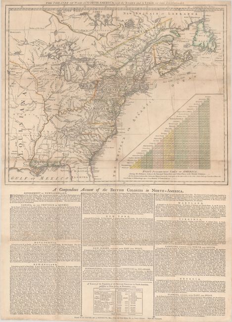
Subject: Colonial Eastern United States & Canada

Period: 1776 (dated)

Publication:

Color: Hand Color

Size:
20.1 x 16.1 inches
51.1 x 40.9 cm
Download High Resolution Image
(or just click on image to launch the Zoom viewer)

This is the first state of an important early broadside by Sayer & Bennett, one of the first printed accounts to inform British readers of the brewing war in America. The map fills the top half of the sheet, extending from the eastern United States and Canada to well beyond the Mississippi River and the "Extensive Meadows" of Louisiana. The southern colonies of Virginia, North Carolina, South Carolina and Georgia have open-ended western boundaries with numerous Indian tribes occupying the trans-Appalachian west. The map is based in part on Lewis Evans' earlier map with up-to-date details including settlements, forts, roads, rivers, topography and more.

The broadside was widely distributed in England for 1 shilling each and provided readers with a view of the North American "theater." The map carries over Evans' use of a distance table between principal cities to convey the colonies' scale. As Nebenzahl notes, the "972 miles shown in the table between Williamsburg and Quebec was considerably farther than the entire north-south length of Great Britain." The bottom half of the sheet features three panels of text primarily describing the physical features and chief towns of each colony. The text does include some more descriptive passages, however, including an account of Charleston which "for size, beauty, and trade, views with the first towns in America" or Virginia which "seems unrivalled throughout the universe for convenience of inland navigation...that every planter here has a river at his door." At bottom is a population table from 1765 showing that the colonies had 600,000 "Men (White and Black) able to bear Arms" out of a total population of 2.4 million. While this figure overstated the actual size of the Continental Army (estimated at 231,000 served, but no more than 48,000 at one time), it dwarfed the size of the British Army at time of publication (approximately 48,000).

This is the first state dated March 20th, 1776. A second entirely different plate was issued just eight months later on November 20, 1776. On a full sheet of English text measuring 20.8 x 28.7".

References: McCorkle #776.26; Nebenzahl & Higginbotham pp. 206-208; Sellers & Van Ee #144; Stevens & Tree (Tooley) #58.

Condition: B+

Issued folding on watermarked paper and now flat with light soiling. The folds have been professionally reinforced on verso to repair numerous fold separations with occasional minor loss at the fold junctions.

Estimate: $10,000 - $13,000

Unsold

Closed on 6/22/2022

Archived