Catalog Archive
Auction 187, Lot 97

First State of One of the Earliest Large-Scale English Maps of North America

"North America Corrected from the Observations Communicated to the Royal Society at London, and the Royal Academy at Paris", Price, Senex & Maxwell

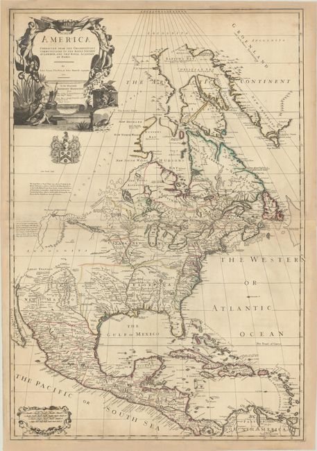
Subject: Colonial North America

Period: 1710 (dated)

Publication:

Color: Hand Color

Size:
25.8 x 37.7 inches
65.5 x 95.8 cm
Download High Resolution Image
(or just click on image to launch the Zoom viewer)

This striking map is based largely on Delisle's cartography and consolidates new information and data into one of the earliest large-scale English maps of North America. Senex's depiction of the Great Lakes region and accurate definition of the lower Mississippi River and its delta are important contributions to the cartography of the period. The map extends to include coverage of the Canadian Arctic and the Terra Incognita above Baffin's Bay, and south to Central America and the West Indies, where Sir William Phipps' discovery of Spanish wrecks off the coast of the Caicos and southern Bahamas is noted. Throughout the map Senex presents known areas in great detail but leaves less-known areas notably blank.

One of the most interesting features of the map is the depiction of Lahontan's mythical Long River, which includes several extensive notations, one of which reveals the controversy concerning these discoveries: "The Long River, or Dead River was discover'd lately by the Baron Lahontan as far as is mark’d in the Map, that which is more to the westward was drawn by the Savages of the Nation of Gnacsitares on Dear Skins. Unless the Baron Lahontan has invented these things, which is hard to resolve He being the only Person that has Travel'd into these vast Countries." Beyond the Nation of Gnacsitares and a mountain range lies the Nation of Mozeemlecks and a large salt lake. The mythical city of Quivira appears north of Taos and a fragment of R of St. Francisco, and Great Teguaio is named north of Apache country.

The map is dedicated to Anthony Hammond, Commissioner in Her Majesty's Navy, with his coat of arms below the large title cartouche. The ornate title cartouche features Native Americans, exotic animals, birds, and plants. This is the first state as identified by Stevens & Tree, with Senex, Price, and Maxwell named in the cartouche and no imprint beneath the distance scales at bottom left. Printed on two joined sheets, as issued.

References: Phillips (Maps) p. 566; Tooley (Amer) p. 91, #61; cf. Wheat (TMW) #92.

Condition: B+

A sharp impression with contemporary outline color on sheets with large fleur-de-lis coat of arms watermarks. The map has been professionally remargined to repair several chips along the sheets' edges. There is light toning along the joint and a bit of minor foxing.

Estimate: $3,500 - $4,250

Sold for: $2,500

Closed on 4/27/2022

Archived