Catalog Archive
Auction 187, Lot 81

Uncommon Map with Interesting Geographical Myths

"Nouvelle Carte de l'Amerique, avec tous ses Royaumes, Etats, Iles, Ports, Bayes et Rivieres, Dressee Suivant les Plus Nouvelles Decouvertes par les Habiles Geographes...", Aa, Pieter van der

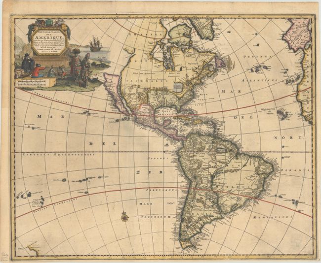
Subject: Western Hemisphere - America

Period: 1714 (circa)

Publication:

Color: Hand Color

Size:
21.2 x 17 inches
53.8 x 43.2 cm
Download High Resolution Image
(or just click on image to launch the Zoom viewer)

Van der Aa's uncommon map of the Americas was first issued in 1714, and includes interesting geographical myths. In North America California is depicted as an Island in the early Sanson form with a nearly flat top beginning at C. Mendocina. Nova Albion is noted in the northern part of the island, and Village des Canots has been inserted between P. de Carinde and P de la Conception. The northwest coast is indented with the Straet Anian separating the continent from Anian. The St. Lawrence River connects with a single large interior lake, which is open-ended in the west. South America is shown with the large, mythical interior lake Parime Lacus in Guyana and Lago de los Xarayes in the center of the continent. A partial outline of Zelandia Nova is shown in the South Pacific. The beautiful title cartouche features Natives trading New World products with European merchants.

References: Tooley (America) #72 (Plt #55); McLaughlin #187.

Condition: B+

A dark impression, issued folding on a sheet with a Strasbourg Bend & Lily watermark. There is printer's ink residue, minor toning, and the top margin has been extended with period-correct paper. Narrow bottom and right margins, as issued.

Estimate: $1,400 - $1,700

Sold for: $1,300

Closed on 4/27/2022

Archived