Catalog Archive
Auction 187, Lot 174

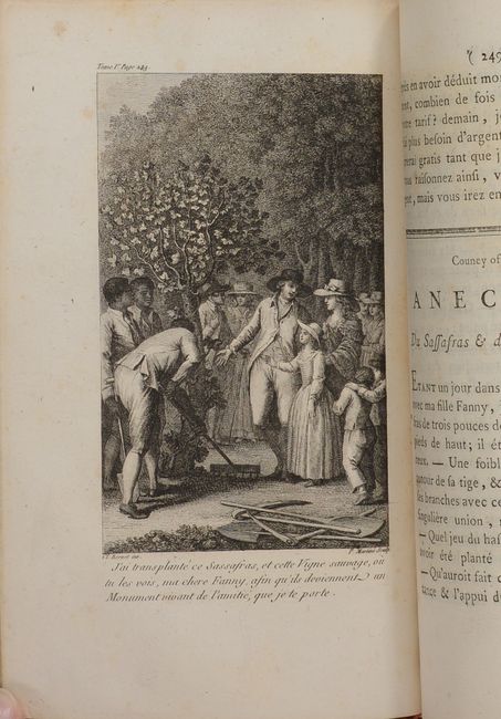
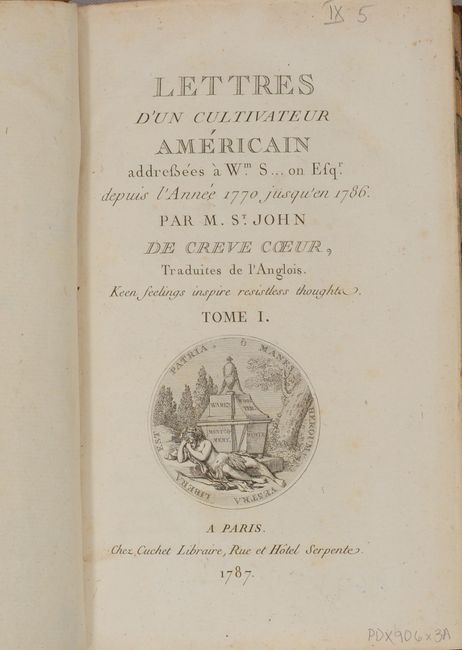
Crevecoeur's Classic Account on American Life

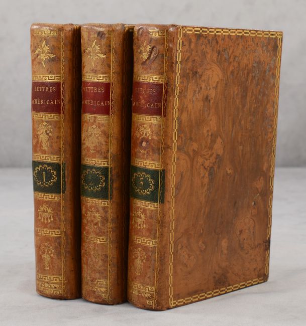
"[Three Volumes] Lettres d'un Cultivateur Americain Addressees a Wm. S... on Esqr. Depuis l'Annee 1770 Jusqu'en 1786...", Crevecoeur, Michel Guillaume De

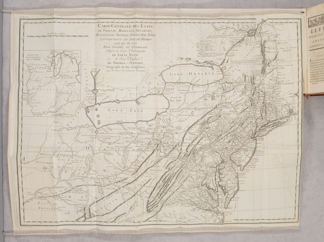
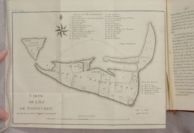
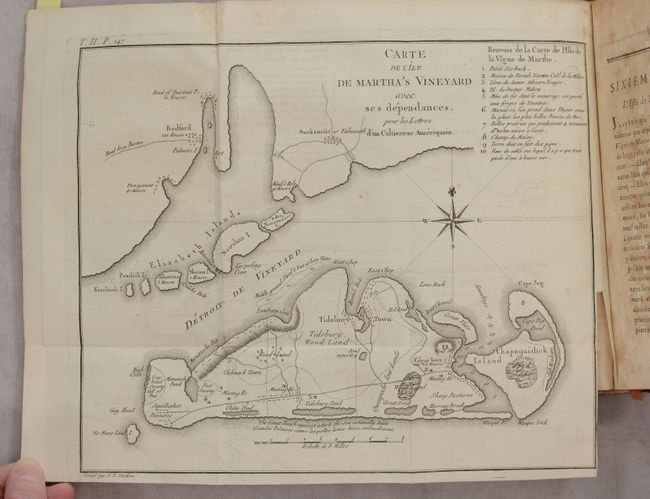
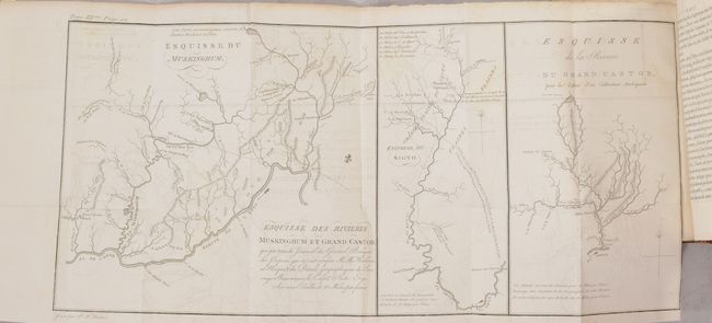
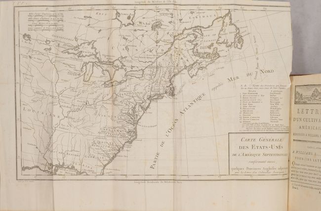
Subject: New England United States

Period: 1787 (published)

Publication:

Color: Black & White

Size:
5.1 x 8.1 inches
13 x 20.6 cm
Download High Resolution Image
(or just click on image to launch the Zoom viewer)

This very attractive three-volume set is Crevecoeur's classic collection of twelve essays that reflected on the nature of American life, particularly its customs and manners. His description of bountiful American lands spurred many French people to immigrate to America. Of special interest, the book contains letters concerning observations of life on the islands of Nantucket and Martha's Vineyard, which are generally considered to provide the first detailed depictions of these islands. Howes says that Crevecoeur's work is a: "Description of American life of great influence in attracting European immigration in the post-revolutionary period. As literature unexcelled by any American work of the eighteenth century." The books include the following 5 maps:

Carte Generale des Etats de Virginie, Maryland, Delaware, Pensilvanie, Nouveau-Jersey, New-York, Connecticut... (25.5 x 18.8"). This is an updated edition of Evans' rare and important map of the Middle Colonies that was first published in 1755. Highly detailed, the map covers the frontier, not just the better known populated areas of the states. It extends to include Lakes Ontario and Erie, and the St. Lawrence River to Montreal. The map randomly uses French or English for the scores of place names, while most notations and the legend are in English. A large inset at upper left "Esquis se duresse de la Riviere de l'Ohio" shows the course of the Ohio River to the Mississippi and up to Lakes Michigan and Huron. The French had better knowledge of the Great Lakes area as evidenced by additions on this map not found on the original Evans. For example, the Portage of Chikago, Fort Erie, and St. Louis are shown and the Niagara River valley contains more detail of the watershed in the region. Crevecoeur also included updated information in New England particularly in Vermont, where Dartmouth College, Putney, Bennington & Westminster are located. Kentucky is erroneously named as a state and there are early references to important cities in the region - Louisville, and Leestown, which was the first Anglo-American settlement on the north side of the Kentucky River and is now part of Frankfort. The map names Indian tribes and a legend explains their status: Extinct; Nearly extinct; and those that are Still considerable. Condition: Light offsetting with a binding tear that extends 0.5" beyond the neatline. (B+)

Carte de l'Ile de Nantucket, pour les Lettres d’un Cultivateur Ameriquain (8.0 x 11.0"). This early copper engraved map of Nantucket includes a legend identifying thirty-two different sites. In addition to the detail in the legend, the map locates Sherburn, Full Mill and Isle de Tuckanuck. Condition: Faint offsetting. (A)

Carte de l'Ile de Martha's Vineyard avec ses Dependances... (10.3 x 8.3"). This rare copper engraved map covers Martha’s Vineyard, the Elizabeth Islands and a portion of Cape Cod. On the Vineyard, details include roads, natural features, towns and villages, and two meeting houses. Also locates Tidsbury Wood Land south of Tidsbury Town, Eel Pond, Peat Swamp, Squidnoket Pastures, and Cape Pog Pond. The legend at upper right identifies ten features on the map with more information. A most desirable and early map of Martha's Vineyard. Condition: Light offsetting and marginal foxing. (B+)

Esquisse du Muskinghum [on sheet with] Esquisse du Sioto [and] Esquisse de la Riviere du Grand Castor (20.5 x 9.0"). Interesting sheet that contains three separate maps showing the Indian villages in the region of the Ohio River. At upper left above neatline is "Tome IIIme. Page 413." Condition: Light offsetting. (B+)

Carte Generale des Etats-Unis de l'Amerique Septentrionale... (16.7 x 10.1"). An uncommon map of the early United States and the first printed map to name Frankland. Also known as Franklinia, it is shown here just west of the border of North Carolina, named Pays de Frankland. In 1785 settlers in western North Carolina and what would become eastern Tennessee organized a state government to be named in honor of Benjamin Franklin. Congress turned down their appeal but the state maintained a legislature and governor until 1788. This ephemeral state appears on only a small number of maps. The 14th state of Vermont is named and noted in the key at right, with a notation in French that it was "not yet accepted in the confederation." Virginia is shown in a strange configuration and there is a square-shaped region denoted as Pays de Kentukey. Condition: There is a short binding tear at right with a small area of loss along the right neatline not impacting the map image. Light offsetting, a bit of foxing, and toning along one fold. (B+)

All maps are engraved by Pierre Tardieu. Matched set in three volumes - volume 1 (478 pp.), volume 2 (438 pp.), volume 3 (592 pp.). Octavo, hardbound in original full calf with gilt title on red and green labels on the spine, marbled endpapers and marbling on the sheet edges. A very attractive offering.

References:

Condition: A

An overall very nice example. Text is generally clean with occasional foxing or soiling. Contents are tight and the binding shows only minimal wear. See description above for the condition of the maps.

Estimate: $3,250 - $4,000

Sold for: $3,500

Closed on 4/27/2022

Archived