Catalog Archive
Auction 187, Lot 122

Dutch Version of an Important Map Showing Territorial Claims at the Outset of the French and Indian War

"Carte des Possessions Angloises & Francoises du Continent de l'Amerique Septentrionale / Kaart van de Engelsche en Fransche Bezittingen in het Vaste Land van Noord America", Ottens, Reiner and Joshua

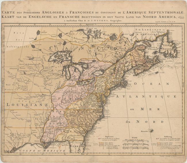
Subject: Colonial Eastern United States & Canada

Period: 1755 (dated)

Publication:

Color: Hand Color

Size:
22.4 x 16.3 inches
56.9 x 41.4 cm
Download High Resolution Image
(or just click on image to launch the Zoom viewer)

This is the Dutch version of Jean Palairet and Thomas Kitchen's important map showing the French and English territorial claims on the eve of the French and Indian War. The Palairet/Kitchen map was in turn based on John Mitchell's index of his large, epic map of the region. The map is filled with meticulously engraved detail of towns, forts, roads, and tribal lands. Beautiful original color delineates the French and British colonies and those lands in dispute between the two powers. The French forts are noted with a tiny, red circle around them. The Great Lakes are beautifully illustrated with Lake Superior still sporting the imaginary island of Philippeaux. Title and notations are in both French and Dutch.

References: McCorkle #755.9; Seller and Van Ee #58.

Condition: B+

On a thick, watermarked sheet with a narrow, but adequate, left margin and professional repairs to a small edge tear at left and a short centerfold separation at bottom. There is light surface soiling and some minor manuscript notations in the image.

Estimate: $1,400 - $1,700

Sold for: $1,300

Closed on 4/27/2022

Archived