Catalog Archive
Auction 186, Lot 99

Moll's Famous "Codfish Map" Reflecting New Boundaries at End of French & Indian War

"To the Right Honourable John Lord Sommers Baron of Evesham ... This Map of North America According to ye Newest and Most Exact Observations...", Moll, Herman

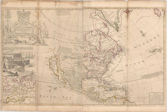
Subject: Colonial North America

Period: 1764 (circa)

Publication:

Color: Hand Color

Size:
37.9 x 23 inches
96.3 x 58.4 cm
Download High Resolution Image
(or just click on image to launch the Zoom viewer)

Moll's map of North America was first published circa 1720 in response to Delisle's influential map Carte de La Louisiane de du Cours du Mississipi published a couple of years prior, in an attempt to counter Delisle's French claims to the Carolinas. This edition was published at the end of the French and Indian War and was updated to show entirely new territorial boundaries, with British claims extending to the Mississippi River and including Florida, which Spain was forced to give to the British due to the First Treaty of Paris in 1763. Spain is still in control of the western United States, and France continues to hold on to Louisiana in the central US.

Interestingly, numerous changes were made to the eastern US, while the western US was left virtually untouched and therefore outdated. This is one of the latest maps still to show California as an island. California is illustrated with an indented northern coast on the second Sanson model, with New Albion depicted according to Sir Francis Drake and Mozeemleck Country and Straits of Annian to the north. Lahontan's fabled R. Longue and great salt lake of the Gnacsitares appear just east of Mozeemleck Country. The map also shows the tracks of Captain Hudson and Captain James' in their searches for a northwest passage in the early 17th century. Ten insets of harbor plans fill the bottom left corner, including Boston, New York, Charlestown, Port Royal, St. Johns, Acapulco, Cartagena, and Havana.

As with many of Moll's large maps, this map incorporates numerous decorative elements. An elaborate title cartouche dominates the upper left corner with a dedication to the Right Honourable Lord John Somers, an English Whig jurist and statesman who is known for his role in the Bill of Rights in England in 1689. The title is flanked by Indians and Eskimos, tropical birds, and the coat of arms of the Somers family with the Latin motto "Prodesse Quam Conspici" (to Accomplish Rather than to Be Conspicuous). A large vignette below the title illustrates the important cod fishing industry in Newfoundland, which lends this map its nickname as the "Codfish Map." The vignette shows numerous steps within the process, including fishing, carrying, salting, pressing, and drying the fish. Engraved by B. Lens and G. Vertue.

Printed for John Bowles "at the Black Horse in Cornhill," Carrington Bowles in "St. Paul's Churchyard," and Robert Sayer "at the Golden Buck in Fleet Street." Printed on two sheets, joined as issued.

References: Goss (NA) #53; McLaughlin #192; cf. Schwartz & Ehrenberg, pl.79; Wheat (TMW) #105.

Condition: B

Contemporary outline color, issued folding with several fold separations that have been closed on verso with archival materials. There is some extraneous creasing at left, light overall soiling, and damp stains along the top edge of the sheet that extend into the image along the folds at top.

Estimate: $4,000 - $4,750

Sold for: $3,000

Closed on 2/9/2022

Archived