Catalog Archive
Auction 186, Lot 197

One of the Most Beautiful Charts of Maryland and the Chesapeake Bay

"Carte Particuliere de Virginie, Maryland, Pennsilvanie, la Nouvelle Iarsey. Orient et Occidentale", Jaillot/Mortier

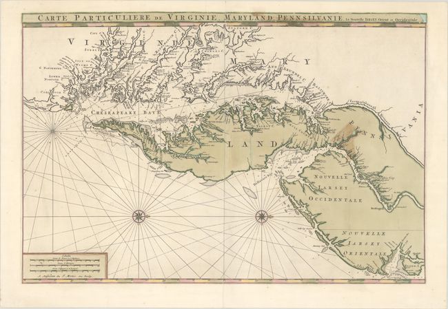
Subject: Colonial Mid-Atlantic United States

Period: 1700 (circa)

Publication:

Color: Hand Color

Size:
31.5 x 21.2 inches
80 x 53.8 cm
Download High Resolution Image
(or just click on image to launch the Zoom viewer)

This large, important nautical chart covers the mid-Atlantic coastline from Staten Island in New York south to Currituck Inlet in North Carolina with the Chesapeake Bay featured prominently. Two compass roses orient north to the right. The chart is a close copy of John Thornton & William Fisher's chart of the same region that appeared in the English Pilot in 1689. Cartographically, it is largely based on the extremely important and rare Augustine Herrman map. The map provides exceptional detail of the waterways including soundings, navigational hazards, and coastal communities. Philadelphia is prominently shown. The chart was prepared by Alexis-Hubert Jaillot, and appeared in the atlas Suite du Neptune Francois in 1700 and Atlas Nouveau in 1708, published by Pierre Mortier, whose imprint is in the distance scale at lower left.

References:

Condition: B

A sharp impression with full contemporary color on a bright sheet with a small "P" watermark. The map has been expertly restored and fully backed in archival tissue to repair a number of cracks caused by the oxidation of the green pigment, with color replaced in a few small areas where chips had resulted. There is a stained area at right due to non-archival tape that had been applied to the map on verso, which was removed and properly repaired by the paper conservator.

Estimate: $4,000 - $5,000

Sold for: $3,000

Closed on 2/9/2022

Archived