Catalog Archive
Auction 185, Lot 2

Ortelius' Famous World Map - First Plate in Full Contemporary Color

"Typus Orbis Terrarum", Ortelius, Abraham
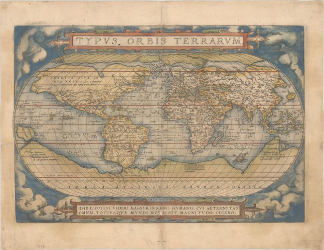
Subject: World

Period: 1571 (published)

Publication: Theatrum Orbis Terrarum

Color: Hand Color

Size:
19.5 x 13.4 inches
49.5 x 34 cm
Download High Resolution Image
(or just click on image to launch the Zoom viewer)

This is the first (of three) world maps that was included in Ortelius' famous atlas. It is a simplified reduction of Mercator's influential map of 1569 presented on an oval projection rather than the projection for which Mercator is now famous. From surviving correspondence, it is known that Mercator encouraged Ortelius and provided him with information, particularly with coordinates of places in the Americas. Placed on a cloud background, the map shows North America as much too wide and South America retains the unusual bulged southwestern coastline. At the poles, a prominent Northwest Passage snakes its way south of the four islands making up the arctic regions, and a huge Terra Australis Nondum Cognita makes up the imaginary southern continent. A notation next to New Guinea notes that it is unknown if this large island is a part of the southern continent. The title is in a strapwork banner at top, which is balanced with a quotation from Cicero at bottom. This superb map was engraved by Frans Hogenberg with his signature at bottom. The plate was used for the first 16 editions of the Theatrum. A crack developed in the lower left corner from 1570 onward. This early edition shows evidence of a short crack, which increased in size in later editions. This is the first state, with Latin text on verso.

References: Shirley #122; Van den Broecke #1.1.

Condition: B

An early impression with full contemporary color on a lightly toned sheet with the crossed arrows watermark commonly found on Ortelius maps, and light soiling. The right half of the map has been professionally backed in thin, archival tissue to repair a tiny crack at bottom right and some separations and two small holes along the centerfold, with a minor amount of the image replaced in facsimile. A short tear that just enters the map image at left has also been archivally repaired.

Estimate: $5,500 - $6,500

Sold for: $4,500

Closed on 11/17/2021

Archived