Catalog Archive
Auction 185, Lot 238

One of the Most Influential Maps of Westward Expansion

"[Map in Book] A New Map of Texas Oregon and California with the Regions Adjoining. Compiled from the Most Recent Authorities [in] A General View of the United States...", Mitchell, Samuel Augustus

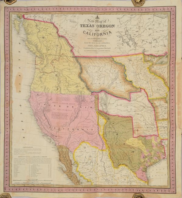
Subject: Western United States, Texas

Period: 1846 (published)

Publication:

Color: Hand Color

Size:
20.7 x 22.3 inches
52.6 x 56.6 cm
Download High Resolution Image
(or just click on image to launch the Zoom viewer)

Mitchell's seminal 1846 map of Texas, Oregon Territory, Upper California, Missouri Territory, Iowa Territory, and Indian Territory is one of the most important and desirable maps in a collection of Western Americana. It was one of the first separately issued, commercial maps to concentrate of the West after the annexation of Texas in 1845 and the beginning of the Mexican-American War in 1846.

During the 1840s there was tremendous interest in understanding the landscape of the West given Texas' recent statehood. Mitchell capitalized on this interest by publishing one of the earliest maps to show the newly formed state. The map provides a snapshot of the most current geographical knowledge of the West. Mitchell’s sources included Arrowsmith’s 1841 map of Texas, Lewis & Clark’s expedition, Nicollet’s map of the region between the Mississippi and the Missouri rivers, Fremont and Emory’s explorations, and Wilkes’ map of the Oregon territory. The map was so esteemed that Lieutenant Emory wrote that it was one of only three maps he thought was worthwhile to carry along when he left Washington in June of 1846 to serve with the Army of the West (the others being Gregg's and Albert's).

Cartographically, the stovepipe configuration shows Texas's northern claim all the way to the 42nd parallel in present day Colorado, following Emory's map, and includes the state's claim to the Upper Rio Grande in present-day New Mexico. These claims were eventually given up in the Compromise of 1850 in exchange for the federal assumption of Texas' public debt. The map displays a large Oregon territory with the northern border well into British Colombia, reflecting United States interests. Large, early configurations of Missouri Territory, Indian Territory and Iowa are also depicted. The Gold Region of California is identified, along with the Oregon Route and the Caravan Route to Santa Fe. The map is filled with information on Indian tribes, rivers, topography and notations regarding the Great Basin. At bottom left is a distance table for places along the Emigrant Route.

The map is typically issued in pocket map form with a 46-page accompaniment, but is offered here bound to the inside front cover of Mitchell's A General View of the United States. The 128 pages of text includes 100 pages of individual descriptions of states, and 28 pages of statistical tables including population, commerce, canals and railroads, and more. The descriptions relating to Texas, California and Oregon are nearly identical between these two versions. Wheat notes that this text "is of particular interest, containing perhaps the clearest statement of Oregon and California facts that came out of the period just prior to settlement of the former's boundaries and inclusion of the latter in the United States." Octavo, hardbound in printed boards.

References: Cohen (Mapping the West) pp. 134-35; Martin & Martin #36; Sabin #49716; Wheat (TMW) #520; Wheat (Gold) #29.

Condition: B

The folding map is good with some minor toning and staining. A short fold separation that just enters the image at top left has been closed on verso with archival tape. Text is bright with a faint dampstain in the lower right corner throughout and some minor foxing. The upper half of the title page has a number of pencil notations. Covers are worn and stained and have been reattached with binder's tape on the spine.

Estimate: $9,500 - $12,000

Sold for: $7,000

Closed on 11/17/2021

Archived