Catalog Archive
Auction 185, Lot 150

Coronelli's Important Map of the Great Lakes & Upper Mississippi River Valley

"La Louisiana, Parte Settentrionalle, Scoperta Sotto la Protettione di Luigi XIV, Re di Francia, Etc. ", Coronelli, Vincenzo Maria

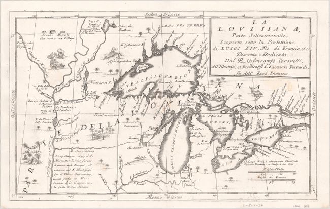
Subject: Colonial Central United States & Canada, Great Lakes

Period: 1696 (circa)

Publication: Atlante Veneto

Color: Black & White

Size:
16.4 x 10.1 inches
41.7 x 25.7 cm
Download High Resolution Image
(or just click on image to launch the Zoom viewer)

Beautiful and important map of the Great Lakes region from the reports of Jesuit missionaries such as La Salle, Joliet, Hennepin and others who traveled along the Mississipi and Great Lakes. R. de Chekagou is shown at the location of present-day Chicago. Lake Superior is shown very accurately, naming the Keweenaw Peninsula (P. Kioanan) and locating Isle Royale (I. Miniong). It does not show the fictitious islands that begin with Bellin later in the 18th century. The map is filled with scenes of natives drying fish, hanging around in hammocks, and an incongruent scene of an alligator swallowing a native. This map is based on a portion of the Nolin/Coronelli map, "Partie Occidentale du Canada ou de la Nouvelle France…," and was introduced in the second edition of Coronelli's important Atlante Veneto (1695-97).

References: Burden #701; Kershaw #163; Karpinski (MI) p. 117.

Condition: B+

A crisp impression on a bright sheet with the watermark of three crescent moons. There are several faint stains and a few small worm tracks in the center of the image that have been professionally repaired, with a minute amount of the image skillfully replaced in facsimile.

Estimate: $2,750 - $3,500

Sold for: $4,500

Closed on 11/17/2021

Archived