Catalog Archive
Auction 185, Lot 113

"Carte de la Californie et des Pays Nord-Ouest Separes de l'Asie par le Detroit d'Anian...", Robert de Vaugondy/Diderot

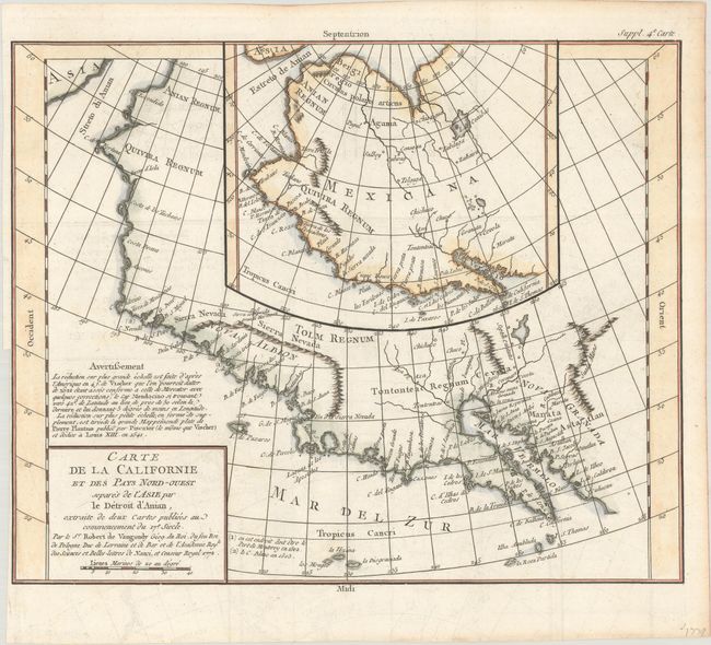
Subject: Western North America

Period: 1772 (dated)

Publication: Diderot's Encyclopedie (Supplement)

Color: Hand Color

Size:
14.3 x 11.5 inches
36.3 x 29.2 cm
Download High Resolution Image
(or just click on image to launch the Zoom viewer)

The Encyclopedie was published under the direction of Diderot from 1751 onward with thousands of articles written by the most prominent philosophers and scientists of the time. These great minds collaborated in the goal of assembling and disseminating the fruits of accumulated knowledge and learning. This massive reference work for the arts and sciences, served to propagate Enlightened ideas. Read a full description of this work and Diderot at Wikipedia.com.

Two contrasting maps, one inset into the other. The inset map is based on a world map by Plancius issued in 1641, while the larger map is based on Visscher's map of 1612. Other than a recognizable Baja California, the maps are filled with the cartographic myths of the 17th century. The northwest coast bulges too far to the west. Both maps feature the seven cities of Cibola gathered around a spurious lake in the American Southwest.

References: Pedley #473; Wagner (NW) #632; Wheat (TMW) #159.

Condition: B+

A crisp impression issued folding, now flat, with light offsetting and a binding trim in the left blank margin close to the neatline.

Estimate: $150 - $180

Sold for: $110

Closed on 11/17/2021

Archived