Catalog Archive
Auction 185, Lot 109

Landmark in American Cartography - First Printed Map to Accurately Depict the Mouth of the Mississippi River

"Carte du Mexique et de la Floride des Terres Angloises et des Isles Antilles du Cours et des Environs de la Riviere de Mississipi...", Delisle, Guillaume

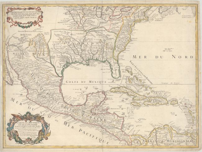
Subject: Colonial Eastern North America & Caribbean

Period: 1703 (dated)

Publication:

Color: Hand Color

Size:
25.4 x 18.7 inches
64.5 x 47.5 cm
Download High Resolution Image
(or just click on image to launch the Zoom viewer)

This important map is credited with accurately showing the course of the Mississippi River and its mouth for the first time. The cartouche attributes the map to Guilluame Delisle, but his father Claude was the main compiler, drawing from the reports of important French expeditions of La Salle, Bienville, and Iberville. It is an attractive map that includes much of the present-day United States, Mexico, Central America, and the Caribbean. The map correctly shows the Great Lakes region, the English settlements along the East Coast, and the early Spanish and Indian settlements in what are now Texas and New Mexico. The early native settlement of Checagou (Chicago) is named on Lake Michigan, called Lac des Ilinois after the native tribe. The name of Checagou refers to the wild garlic that grew abundantly there. Delisle's depiction of the Missouri River is a considerable improvement from his 1700 map of North America, shifting its course from due east to due northwest and separating the R. de St. Francisco from the river. Grand Teguaio habite par les Tiguas appears above the upper Rio Grande Valley. The southwest area of the map is mapped using Father Eusebio Kino's 1696 manuscript as a source. The map influenced later delineations of the Mississippi River by Seutter, Homann, Lotter, and others for many years. The decorative cartouche was engraved by C. Simmoneau. This is the third state, with the author's address at "le Quai de l'Horloge" and Renard's imprint erased in the distance scale cartouche.

References: Brown (IMCOS #165) pp. 37-39; Cumming (SE) #137; Lemmon plt #16; Tooley (Amer) #50, p. 22; Wheat (TMW) pp. 58-61; Schwartz & Ehrenberg, pl. 82.

Condition: B+

On a watermarked sheet with light soiling. There are centerfold separations at top and bottom and some edge tears that have all been repaired with archival materials on verso.

Estimate: $2,750 - $3,500

Unsold

Closed on 11/17/2021

Archived