Catalog Archive
Auction 184, Lot 78

Blaeu's Stunning Carte-a-Figures Map of the Americas in Full Contemporary Color

"Americae Nova Tabula", Blaeu, Willem

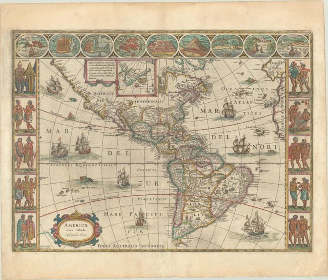
Subject: Western Hemisphere - America

Period: 1642 (circa)

Publication:

Color: Hand Color

Size:
21.8 x 16.1 inches
55.4 x 40.9 cm
Download High Resolution Image
(or just click on image to launch the Zoom viewer)

This stunning carte-a-figures map is a superb example of the fine art of decorative cartography and a seventeenth-century European view of the New World. The coastal outlines generally follow Ortelius and Wytfliet with nomenclature from a variety of explorers and colonists. Panels at sides, each with five portraits of the native inhabitants, were taken from John White (Virginia), Hans Staden (Brazil) and other early explorer's accounts. Across the top are nine town plans including Havana, St. Domingo, Cartegena, Mexico City, Cusco, Potosi, I. la Mocha in Chile, Rio de Janeiro and Olinda in Brazil. This is one of the few maps of the Americas by this famous Dutch cartographer. The map itself is similar to Blaeu's wall map of 1608 with the additional discoveries of Henry Hudson in North America, and Tierra del Fuego with Le Maire Strait. This is the fourth state of the plate with the imprint changed to Auct: Guiljelmo Blaeuw and some re-engraving of the sea surrounding the ships and sea monsters. Dutch text on verso, published between 1642-58.

References: Burden #189; Goss (Blaeu) p. 156; Tooley (Amer) p. 297; Van der Krogt (Vol. II) #9000:2.

Condition: B+

A dark impression with full contemporary color, light printer's ink residue, a few small abrasions along the centerfold, and professional repairs to a few minor separations along the centerfold. There is marginal soiling, a crease at bottom right, and light dampstains along the edges of the sheet.

Estimate: $4,750 - $6,000

Sold for: $3,000

Closed on 9/15/2021

Archived