Catalog Archive
Auction 184, Lot 75

Speed's Popular Carte-a-Figures Map of the Americas

"America with Those Known Parts in That Unknowne Worlde Both People and Manner of Buildings Discribed and Inlarged", Speed, John

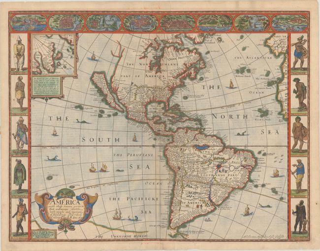
Subject: Western Hemisphere - America

Period: 1626 (dated)

Publication: A Prospect of the Most Famous Parts of the World

Color: Hand Color

Size:
20.2 x 15.5 inches
51.3 x 39.4 cm
Download High Resolution Image
(or just click on image to launch the Zoom viewer)

This English map of the Americas is the earliest folio atlas map to depict California as an island, thus propagating one of the most enduring cartographic myths. It is also significant for its accurate depiction of the coast between Chesapeake and Cape Cod, and early portrayal of the English colonies, Iames Citti (Jamestown) and Plymouth. Boston and Long Island are not shown. The spurious islands of Brasil and Frisland still appear in the Atlantic. An inset map shows Greenland and Iceland. The map is the superb workmanship of the Dutch engraver, Abraham Goos. It is decorated in the popular carte-a-figures style with panels of costumed native figures at each side and vignettes of major cities at top. The figures at left represent the native people of North America, and at right the major South American tribes. The cities illustrated include Havana, Mexico City, Rio de Janeiro, Cusco, and other important South American settlements. A number of sea monsters, flying fish and sailing ships also decorate the map. Dated in the cartouche 1626, published circa 1676 with the imprint of Basset and Chiswell in the cartouche below title. English text on verso.

References: Burden #217; McLaughlin #3; Tooley (Amer) p. 113, #5; Shirley (BL Atlases) T.SPE-2f.

Condition: A

A sharp impression on a bright sheet with a small fleur-de-lis watermark, some minor cockling of the paper, and a few tiny tears along the edges of the sheet that have been archivally repaired on verso.

Estimate: $7,000 - $8,500

Sold for: $5,000

Closed on 9/15/2021

Archived