Catalog Archive
Auction 184, Lot 69

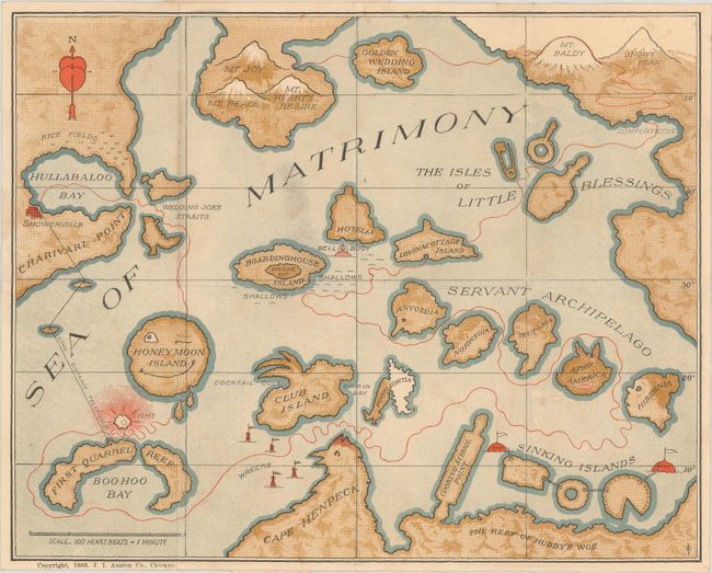
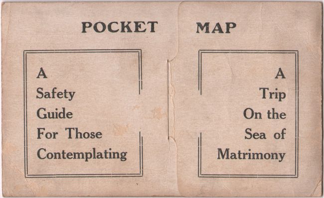
Charming Map and Itinerary for a Successful Marriage

"A Safety Guide for Those Contemplating a Trip on the Sea of Matrimony",

Subject: Cartographic Miscellany, Fictional Map

Period: 1906 (dated)

Publication:

Color: Printed Color

Size:
10.8 x 8.6 inches
27.4 x 21.8 cm
Download High Resolution Image
(or just click on image to launch the Zoom viewer)

This charming map serves as a guide to the joys and pitfalls of marriage, and is accompanied by a humorous "itinerary" to lead couples on a safe route from their nuptials to the mountains of joy, peace and heart's desire. The route is marked in red on the map and begins in Showerville, quickly passing through Hullabaloo Bay (with rice fields along the shore signifying the rice thrown at weddings) and Wedding Joke Straits on to Honeymoon Island. Interestingly, a long-distance telephone line is illustrated between Showerville and First Quarrel Reef, a nod to the first telecommunications lines that were installed in the United States around the turn of the century. The Itinerary warns against "wrecking" on Club Island, Footlightia, Cape Henpeck, Cooking School Point or the Sinking Islands, which represent some of the marital woes that couples can experience, such as husbands spending too much time dancing or at clubs, and wives nitpicking their spouses or fattening up with too many baked goods. The Servant Archipelago consists of five islands in the shapes of heads and named for various groups of caregivers, such as Afro-America and Hibernia. The Itinerary favors stopping at Lovinacottage Island rather than Boardinghouse Island or Hotelia, after which the route continues on to the Isles of Little Blessings, meaningfully in the shapes of a diaper pin, a rattle and a baby bottle. The final stops on the trip are Comfort Cove and Golden Wedding Island before arriving at Mt. Joy, Mt. Peace and Mt. Heart's Desire.

The map folds into stiff printed paper wrappers with the Itinerary on the interior, and the wrappers fold into a postcard via a tongue and slit closer. This example was mailed to Mabel C. Bierman in Columbiana, Ohio in 1910. The map was apparently helpful, as she married Jesse S. Rupert that same year and they subsequently had 6 children.

Published by J. I. Austen Co. in Chicago, one of the leading publishers of postcards in the United States in the early 20th century. The artist's initials "ICK" are printed at bottom right, although the identity of the artist is still unknown.

References:

Condition: B+

The map has a light stain where it was glued onto the paper wrappers, and minor soiling along a few folds. The wrappers are lightly soiled with some small abrasions in the interior.

Estimate: $220 - $250

Sold for: $160

Closed on 9/15/2021

Archived