Catalog Archive
Auction 184, Lot 652

Rare, Early Woodblock Map Based on Ptolemy

"Octava Asie Tabula", Ptolemy/Waldseemuller

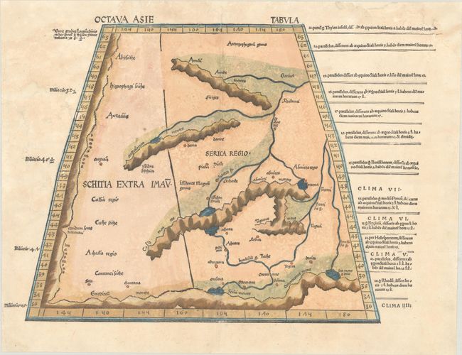
Subject: Central Asia

Period: 1520 (published)

Publication: Ptolemaeus Auctus Restitutus, Emaculutus, cum Tabulis Veteribus ac Novis

Color: Hand Color

Size:
20 x 14.8 inches
50.8 x 37.6 cm
Download High Resolution Image
(or just click on image to launch the Zoom viewer)

Claudius Ptolemy was a mathematician, astronomer and geographer who worked in Alexandria, then a part of the Roman Empire, in the 2nd century AD. One of the most learned and influential men of his time, his theories dominated both astronomy and geography for nearly 1500 years. His writings were kept alive by Arabic scholars during the Middle Ages and reemerged in Europe during the Renaissance. The birth of printing led to wide dissemination of his great works on astronomy and geography. There were a number of editions of his Geographia beginning in 1477. These early editions contained maps based on his original writings, known as Ptolemaic maps. As geographic knowledge increased with the explorations of Columbus, Magellan, Cabot and others, maps of the New World were added, and maps of the Old World were revised. Ptolemy's Geographia continued to be revised and published by some of the most important cartographers including Martin Waldseemuller, Sebastian Munster, Giacomo Gastaldi, Jodocus Hondius, and Gerard Mercator (whose last edition was published in 1730).

Rare woodblock map illustrating the Ptolemaic concept of the central Asian steppe, ancient Schytia Extra Imaum, in a trapezoidal projection. The kingdom of Serica is shown, which is thought to represent "land where silk comes from." This rare Ptolemaic map appeared in the 1513 and 1520 editions of Waldseemuller's Geographia. Waldseemuller's work was the first to supplement the traditional Ptolemaic maps with 20 "modern" ones, creating the first modern atlas and representing a landmark in the history of cartography. This example is from the second edition, as evidenced by the numbers of the climatic zones indicated by Roman numerals.

References: Mickwitz & Miekkavaara #207-43; Shirley (BL Atlases) T.PTOL-6d.

Condition: B

A nice impression on paper with a small fleur-de-lis watermark. There are a number of small worm holes and worm tracks in mostly blank areas of the image at top left that have been professionally repaired. Additional worm holes in the blank margins and chips in the top corners of the sheet have also been professionally repaired. Despite the repairs, the map presents itself very well.

Estimate: $2,400 - $3,000

Unsold

Closed on 9/15/2021

Archived