Catalog Archive
Auction 184, Lot 47

Mortier's Lavish Map of the Poles

"Les Deux Poles Arcticque ou Septentrional, et Antarcticque ou Meridional, ou Description des Terres Arctiques et Antarcticques...", Sanson/Mortier
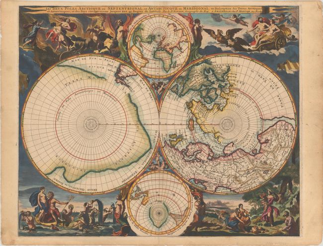
Subject: Polar

Period: 1720 (circa)

Publication: Atlas Nouveau...

Color: Hand Color

Size:
20.9 x 17.2 inches
53.1 x 43.7 cm
Download High Resolution Image
(or just click on image to launch the Zoom viewer)

This lavish map of the poles combines the geographical detail of Nicolas Sanson's polar map first issued in 1657 with the decorative elements of Nicolas Visscher's world map of 1658. In the Northern Hemisphere, Greenland is depicted attached to the American continent, and three large islands comprise the Canadian Arctic. It is hinted that Terre de Yezo, ou Iesso takes up the entire North Pacific region between Buttons Bay and East Asia and is connected to North America. In the Southern Hemisphere, the tip of South America is shown with the Strait of Magellan and Le Maire Strait. The balance of the map is filled with a large landmass labeled Terre Magellanicque, Australe, et Incogneue. Surrounding the twin hemispheres are dramatic scenes drawn by Nicolas Berchem for Visscher's map. These superb engravings represent the abduction of Persephone by Hades, Zeus being carried across the heavens in an eagle-drawn chariot, Poseidon commanding his entourage, and Demeter receiving the fruits of the Earth. Inset between the cusps are smaller polar projections, each flanked by allegorical representations of Fire, Air, Water and Earth.

References: Kershaw #146; Phillips (Atlases) #3448-14.

Condition: A

Bold color with a short centerfold separation at bottom that has been closed on verso with old paper. The top sheet edge has been reinforced with old paper on verso and there are remnants of both paper and hinge tape from a previous framing.

Estimate: $4,000 - $4,750

Sold for: $3,000

Closed on 9/15/2021

Archived