Catalog Archive
Auction 184, Lot 463

Speed's Carte-a-Figures Map of England and Wales

"The Kingdome of England", Speed, John

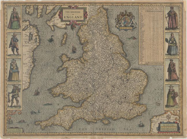
Subject: England & Wales

Period: 1632 (dated)

Publication: The Theatre of the Empire of Great Britaine...

Color: Hand Color

Size:
20.3 x 15.2 inches
51.6 x 38.6 cm
Download High Resolution Image
(or just click on image to launch the Zoom viewer)

This is Speed's handsome carte-a-figures map of England and Wales, based on the work of Christopher Saxton and filled with details of towns and counties. The map is flanked by male and female pairs, including a lady and nobleman, a gentleman and gentlewoman, a citizen and his wife, and a countryman and his wife. At top right is a table indicating the number of cities, bishoprics, markets, rivers, bridges, etc. in each shire. The map is embellished with two strapwork cartouches, the Royal coat of arms, and several sea monsters and galleons. This is the first edition of the second plate engraved by Abraham Goos and closely following Hondius' original which was wearing thin and required replacement. The imprint of George Humble is located at bottom right. English text on verso.

References: Shirley (BI to 1650) #318; Shirley (BL Atlases) T.SPE-1f.

Condition: B+

On watermarked paper with several small fold separations that have been archivally repaired on verso along with a few minor abrasions on the lower centerfold. There are a few tiny holes only visible when held to light and several repairs to edge chips confined to the blank margins.

Estimate: $1,800 - $2,200

Sold for: $900

Closed on 9/15/2021

Archived