Catalog Archive
Auction 184, Lot 42

Rare Medieval World Map

"[Untitled - Ancient World]", Anon.

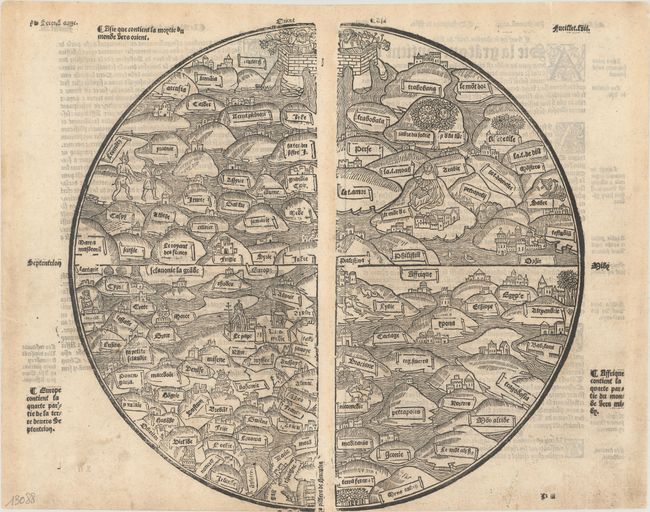
Subject: Ancient World

Period: 1553 (circa)

Publication: Mer des Histoires

Color: Black & White

Size:
12.9 x 11.9 inches
32.8 x 30.2 cm
Download High Resolution Image
(or just click on image to launch the Zoom viewer)

This fine woodcut illustration is a rare medieval world map based on the Rudimentum Novitiorum, a popular world history first published in 1475. The Rudimentum Novitiorum was the first publication to include printed maps depicting land forms and countries (one of the world and one of Palestine), and was popularized through its French translation, Mer des Hystoires. This latter work first appeared in 1488 with new woodblocks, on a slightly smaller scale and with the titles translated into French. A third set of woodblocks were cut in 1491, again slightly reduced in size, and with a few minor changes. The 1491 blocks were reused in several editions through circa 1555. This circular world map is shown with east at the top, centered on Palestine. Europe is depicted at bottom left, with numerous countries identified and an illustration of the Pope in the walled city of Rome. The various countries of Asia and Africa are shown as mountains surrounded by water, and include small illustrations of cities, animals, dragons, and the mythological figure of Pan. At the top of the map is a large walled orchard with two priestly figures in place of the traditional Adam and Eve, while at bottom are the pillars of Hercules. This example is from the 1491 block, reprinted circa 1553. On two sheets, joined.

References: Shirley #17.

Condition: B+

A nice impression on watermarked paper with light soiling. The bottom edge was trimmed by the bookbinder, with loss of the wind direction at bottom.

Estimate: $18,000 - $20,000

Sold for: $13,500

Closed on 9/15/2021

Archived