Catalog Archive
Auction 184, Lot 385

Popple Sheet in Full Contemporary Color

"[A Map of the British Empire in America (Sheet 14) - Cuba, Bahamas, Jamaica]", Popple, Henry

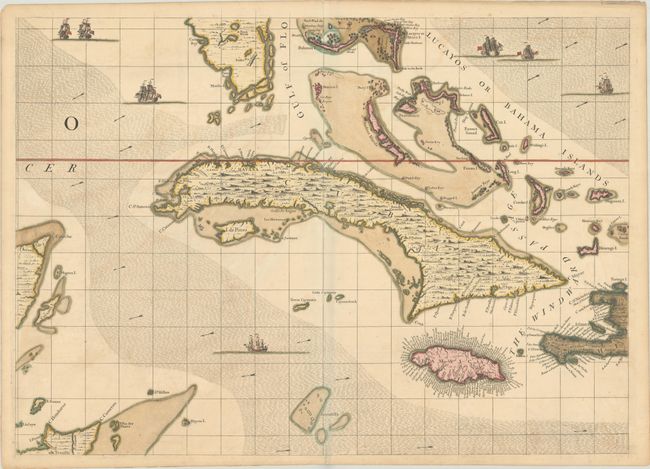
Subject: Greater Antilles

Period: 1733 (circa)

Publication:

Color: Hand Color

Size:
26.9 x 19.3 inches
68.3 x 49 cm
Download High Resolution Image
(or just click on image to launch the Zoom viewer)

Seven intricately drawn ships navigate the ocean currents of this finely engraved map. Sheet 14 of Popple's 20-sheet map of the British Empire in North America focuses on Cuba and extends to include the tips of the Yucatan, Hispaniola and Florida. It also provides excellent detail of the Bahamas and Jamaica. Popple based his map on firsthand information gathered over several years at the Board of Trade and Plantations. The map was the first large-scale British map to provide an overall view of the eastern half of North America. As tensions grew between the colonial powers, the map became immensely influential throughout Europe and was copied by several cartographers. This is an early state printed on sturdy paper watermarked "HONIG" and no page number in top margin.

References:

Condition: A

Nice impression and full contemporary color on a sheet with "Honig" and Strasbourg Lily watermarks. There are archival repairs to a minor centerfold separation at bottom and a short edge tear at top.

Estimate: $2,000 - $2,300

Sold for: $1,700

Closed on 9/15/2021

Archived