Catalog Archive
Auction 184, Lot 370

Mammoth Atlas Volumes from the Mexican Boundary Resurvey

"[2 Volumes] Boundary Between the United States and Mexico, as Surveyed and Marked by the International Boundary Commission... [and] Linea Divisoria Entre Mexico y los Estados Unidos...",

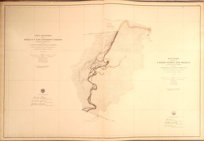
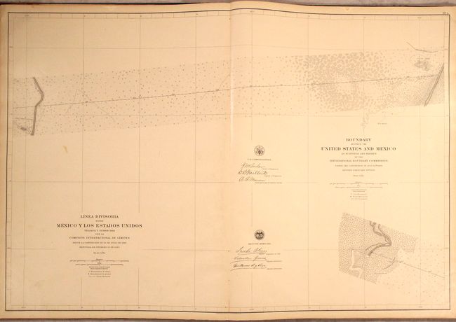
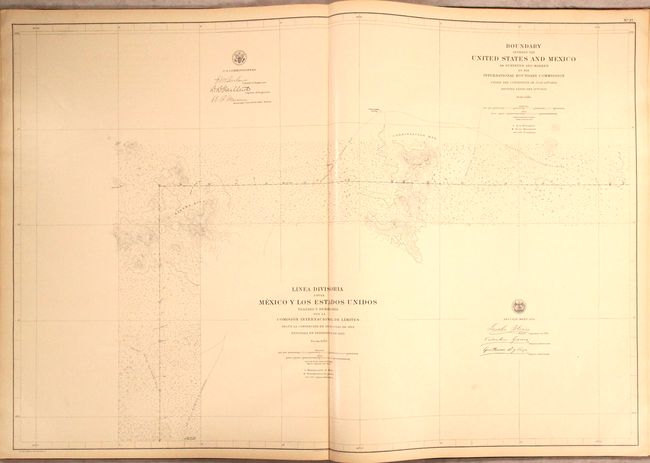
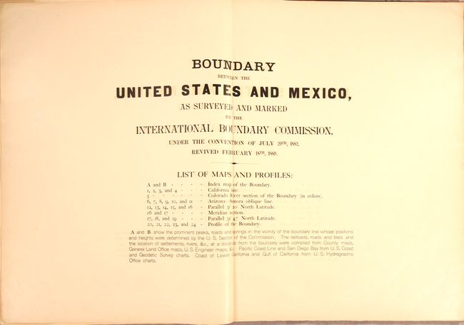
Subject: Southwestern United States & Mexico, Atlas

Period: 1898 (published)

Publication: Sen. Ex. Doc. 247, 55th Congress, 2nd Session

Color: Printed Color

Size:
22 x 29 inches
55.9 x 73.7 cm
Download High Resolution Image
(or just click on image to launch the Zoom viewer)

This lot contains both the Mexican and U.S. atlas editions published in conjunction with the resurveying of the U.S.-Mexican boundary in the late 19th century.

After the Treaty of Guadeloupe, Hidalgo (1848), which ended the war with Mexico, it was necessary to establish a boundary acceptable to both Mexico and the United States. The Mexican Boundary Survey (1855-57) was the result and it provided Americans with the first detailed (but hardly perfect) description of their newly acquired territory.

As time passed and population growth pushed settlement along the boundaries, disputes over the precise location of the border became more common. As a result of these controversies, a new joint commission was formed (1891-94) with the goal of resurveying the original line and either rebuilding the old stone markers or constructing new ones. Commissioners John Whitney Barlow (U.S.) and Jacobo Blanco (Mexico) led the resurvey efforts and grew the number of markers from 52 (many of which were damaged or destroyed) to 258. The new markers were 6-feet tall and constructed of steel and set in concrete (and in some cases fences were erected to protect them). Plaques on each marker read: "Boundary of the United States [or Mexico], treaty of 1853, reestablished by the treaties of 1882–1889."

The contents of the atlases offered here show the commission's remarkable and arduous work from El Paso to San Diego. The U.S. atlas (part of a three-volume set published by the Boundary Commission) includes 26 sheets and is composed of 2 index maps, 19 detail maps, and 5 profile views. The Mexican atlas contains the same 19 detail maps without the index or profile views. Additionally, the Mexican version begins at El Paso while the U.S. atlas begins at San Diego. Each map measures approximately 39" x 23" with dual language titles and locates monuments, boundaries, topography, vegetation, rivers, and much more.

Double elephant folio. Rebacked in faux red leather over green cloth boards with gilt title label on the front cover.

References:

Condition: A

Maps are clean, bright and near fine to fine with a few minor edge tears. The U.S. atlas contains stamps of the Surveyor General's Office on the front pastedown. Rebacked over original boards, which are lightly worn and scuffed with bumped edges.

Estimate: $2,400 - $3,000

Sold for: $1,600

Closed on 9/15/2021

Archived