Catalog Archive
Auction 184, Lot 101

Coronelli's Stunning and Influential Map of North America with the Island of California

"[On 2 Sheets] America Settentrionale Colle Nuove Scoperte sin all' Anno 1688 Divisa Nelle sue Parti Secondo lo Stato Presente e Descritta...", Coronelli, Vincenzo Maria

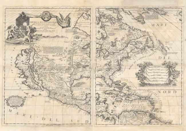
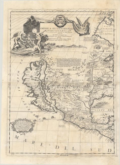
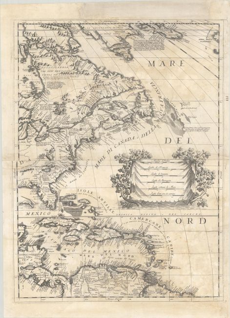
Subject: Colonial North America

Period: 1688 (dated)

Publication: Atlante Veneto

Color: Black & White

Size:
17.9 x 23.8 inches
45.5 x 60.5 cm
Download High Resolution Image
(or just click on image to launch the Zoom viewer)

This exquisitely engraved map of the continent is one of Coronelli's most impressive achievements, showcasing both his scientific rigor and impeccable aesthetic sense, along with some striking cartographic misconceptions. The most noticeable of these misconceptions is the appearance of the island of California in the Foxe configuration with indented bays in the northern coastline as well as a mountain range that runs along its eastern coast. To the southwest of the island, Italian text in a garlanded cartouche references the possibility that California may be a peninsula. The map also depicts the Mississippi River emptying into the Gulf of Mexico 600 miles too far to the west, a cartographic error based on La Salle. As the royal cosmographer of the Republic of Venice and a favorite of Louis XIV of France, Coronelli had access to court documents featuring accounts of the latest expeditions, including the manuscripts of La Salle. Teguiao and Quivira are located around some mountains to the north of Taos. The spurious Lake May is prominently shown in the southeast. There is an extraneous peninsula in New England.

Aside from these cartographic myths, the map features some of the most up-to-date cartography of its era. The cartography of the Great Lakes draws from the accounts of Louis Jolliet, Jacques Marquette, and Louis Hennepin, and, as a result, it is the most precise mapping of the region yet. Whereas other cartographers of the era presented the Rio Grande terminating in the Gulf of California, Coronelli draws from the accounts of Diego Dionisio de Penalosa Briceno y Berdugo and accurately shows it exiting into the Gulf of Mexico. He divides the river into the Rio Norte and Rio Bravo.

The landscape is filled with notes on various expeditions and small exaggerated illustrations of Indigenous life, including an alligator attack, a cannibals' feast, and a few village views. Sea monsters and natives in canoes appear in the Gulf of Mexico. There is a large decorative title cartouche at top left featuring allegorical figures and symbols related to exploration in the New World. Another large cartouche enclosing six distance scales appears in the Atlantic. The map is dedicated to Marsili, Archbishop of Bologna.

References: Burden #643; McLaughlin #103; Shirley (BL Atlases) T.CORO-7a #12 & 13; Tooley (America), p. 125, #57; Wheat [TMW] #70.

Condition: C+

There is water damage across both sheets with several chips and tears that have been repaired on verso with archival materials. Large sections of the map have been replaced in skillful and seamless facsimile, including much of the areas around Iceland and northern South America, and smaller areas in the title cartouche and in the lower border and Mare du Sud on the western sheet. The C+ grade is due to the amount of facsimile work, although all of the most interesting geographical detail mentioned in the description is original. The first image is a composite image - the map is in two separate sheets.

Estimate: $5,500 - $7,000

Sold for: $4,000

Closed on 9/15/2021

Archived