Catalog Archive
Auction 183, Lot 511

"Aphricae Tabula I", Munster, Sebastian

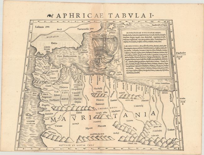
Subject: Northwestern Africa

Period: 1540 (published)

Publication: Geographia Universalis

Color: Black & White

Size:
13.4 x 10 inches
34 x 25.4 cm
Download High Resolution Image
(or just click on image to launch the Zoom viewer)

Sebastian Munster (1489 - 1552) was one of the three most renowned cartographers of the sixteenth century, along with Mercator and Ortelius. Munster's Geographia and Cosmographia Universalis were two of the most widely read and influential books of the period. His editions of Ptolemy's Geographia, published between 1540 and 1552, were illustrated with 48 woodcut maps, the standard 27 Ptolemaic maps supplemented by 21 new maps. These new maps included a separate map of each of the known continents and marked the development of regional cartography in Central Europe. The antique geography was a prelude to Munster's major work, the Cosmographia, which was published in nearly 30 editions in six languages between 1544 and 1578 and then was revised and reissued by Sebastian Petri from 1588 to 1628. The Cosmographia was a geographical as well as historical and ethnographic description of the world. It contained the maps from the Geographia plus additional regional maps and city views with nearly 500 illustrations which made it one of the most popular pictorial encyclopedias of the sixteen century.

This bold Ptolemaic map covers Mauritania - present-day Morocco, Algeria, and Tunisia. The interior is dominated with convoluted mountain ranges, most of them entirely spurious. The Strait of Gibraltar is marked Columna Herculis (Pillars of Hercules) and a large sailing ship is shown in the Mediterranean. Published in the first edition of Munster's Geographia Universalis.

References: Mickwitz & Miekkavaara #210-13.

Condition: B+

A nice impression on paper with a small crown watermark, minor soiling, and light toning along the centerfold.

Estimate: $300 - $375

Sold for: $220

Closed on 6/9/2021

Archived