Catalog Archive
Auction 183, Lot 499

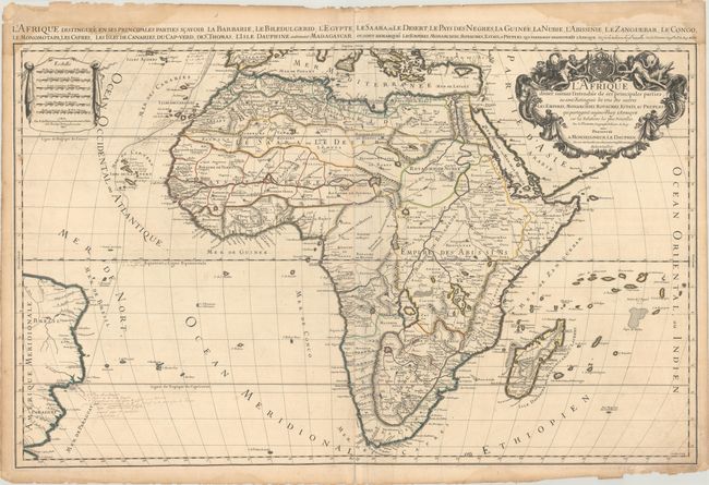
"L'Afrique Divisee Suivant l'Estendue de ses Principales Parties ou sont Distingues les uns des Autres les Empires, Monarchies, Royaumes, Estats, et Peuples...", Sanson/Jaillot

Subject: Africa

Period: 1674 (dated)

Publication:

Color: Hand Color

Size:
35 x 21.6 inches
88.9 x 54.9 cm
Download High Resolution Image
(or just click on image to launch the Zoom viewer)

This striking map is the rare first state of Jaillot's map of the continent and is a larger version of Sanson's maps of 1650 and 1668. Engraved by Cordier, it is one of the early works in the collaboration between Sanson and Jaillot. The source of the Nile is shown emanating from two lakes below the equator. This map introduces a new depiction of the rivers south of these Ptolemaic lakes. The Zambeze River appears above the Zambere and Rio de Spiritu Santo, all of which flow into the Indian Ocean. A large section of South America is shown and two St. Helena islands appear - a common error in maps from this period. The large distance scale cartouche has six scales. The very large and decorative title cartouche includes a tumult of figures, cornucopias, elephant, crocodile, lion and ostrich under the coat of arms of the Dauphin. Two sheets joined, as issued. This is the first state. This important map of the continent was copied by several other cartographers including Pieter Mortier and Marc Huguetan, who published their own edition of Jaillot's Atlas Nouveau in 1692, with Jaillot's imprint instead of their own.

References: Betz #118; Norwich #46; Tooley (AF) p.56, plt. #41.

Condition: B

A dark impression on sheets with Society of Jesus watermarks, light soiling, extraneous creasing adjacent to the centerfold, and a centerfold separation at bottom that enters 1" into the image. There is a damp stain along the top edge of the sheet that enters the map image at top left, and there are some small chips and tears along the edges of the sheet.

Estimate: $1,000 - $1,300

Sold for: $500

Closed on 6/9/2021

Archived