Catalog Archive
Auction 183, Lot 248

One of the Few Maps to Include "Republic" in the Title

"Mexico & Guatimala, with the Republic of Texas", Lizars, William Home

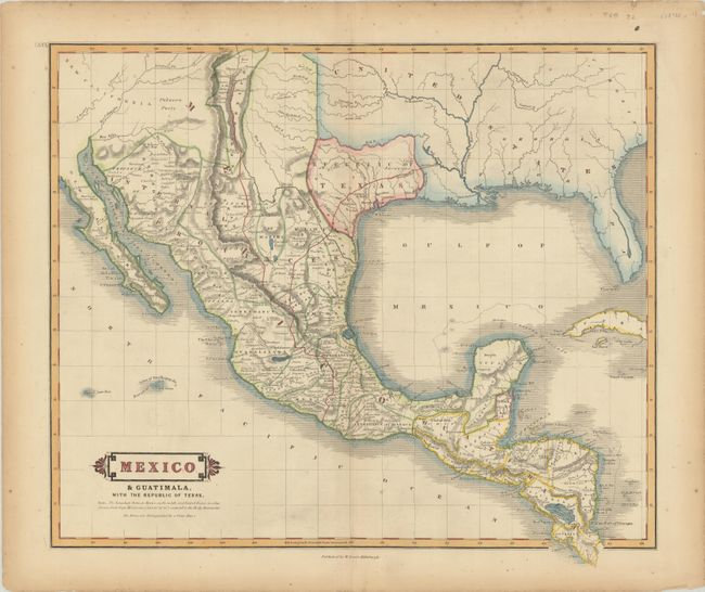
Subject: Southern United States, Mexico & Central America, Texas

Period: 1838 (circa)

Publication:

Color: Hand Color

Size:
19.2 x 16.6 inches
48.8 x 42.2 cm
Download High Resolution Image
(or just click on image to launch the Zoom viewer)

This handsome and scarce map prominently features the Republic of Texas, and depicts the southern United States, Mexico, and Central America. The Independent Republic of Texas is bound by the Red River in the north, the Sabine River in the east, and in between the Nueces and Rio Grande (Rio Bravo del Norte) rivers in the south. Mexico is divided into the Intendancies, and Guatemala takes in all of Central America except for the British colony of Belize. New Mexico is shown as a narrow strip of land along the upper Rio Grande River, and most of New California is noted as Unknown Parts. The roads (El Camino Real) connecting Natchitoches and Santa Fe with Mexico City are prominently delineated, and numerous mines are located with small crosses. A desirable map for any Texas collection.

References:

Condition: B+

A crisp impression with minor soiling, a few spots of foxing, and short centerfold separations confined to the top and bottom blank margins. There is light toning along the sheet edges.

Estimate: $1,100 - $1,400

Sold for: $850

Closed on 6/9/2021

Archived