Catalog Archive
Auction 183, Lot 110

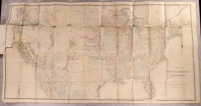
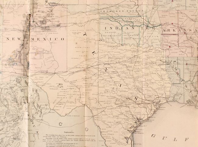
"[Map in Book] Map of the United States and Territories, Showing the Extent of Public Surveys and Other Details... [in] Report of the Commissioner of General Land Office, for the Year 1867", General Land Office

Subject: United States

Period: 1867 (published)

Publication:

Color: Hand Color

Size:
55.2 x 28.6 inches
140.2 x 72.6 cm
Download High Resolution Image
(or just click on image to launch the Zoom viewer)

This is one of the more remarkable maps produced by the General Land Office. It shows the extent of the Public Surveys just after the Civil War and includes many features of great interest. Most significant are the gold, silver, copper, and other mineral deposits that are color-coded to mark their location. The sites of army forts and posts provide an excellent view of the undeveloped territories and the western frontier. Details include land grants, townships, subdivisions, railroads, mining districts, etc. Present-day Wyoming is unnamed and shown as part of the Dakota Territory. In the West, survey progress is still limited with much of Southern California complete, but only small areas of New Mexico and Arizona are complete, and with no surveys at all in Utah, Montana and Wyoming. The geological key also locates, via color and icon, deposits of quicksilver, iron, tin, asphalt, coal and oil springs that are shown scattered throughout the country. Constructed from Plats and Official Sources of the General Land Office under the direction of Hon. J.S. Wilson, Commissioner, by Joseph Gorlinski. Signed in the plate by Wilson. The General Land Office (GLO) was created in 1812 to oversee local land offices and in 1849 was incorporated into the Department of Interior.

The map is still bound into the back of the 371-page annual report. Octavo, hardbound in pebbled green cloth with gilt title on spine.

References: Wheat (TMW) #1168.

Condition: B

The large folding map, in original color, is good with light dampstains along the fold lines and numerous fold separations along the upper horizontal fold and right vertical fold. An edge tear at left extends 5" into the image. Text is mostly clean and tight with some faint dampstaining in the lower half of the first 50 pages. There are library stamps on title page and front free endpaper. Covers have some minor staining and the edges are bumped.

Estimate: $300 - $375

Sold for: $220

Closed on 6/9/2021

Archived