Catalog Archive
Auction 182, Lot 72

Homann's Early Edition Featuring the Island of California

"Totius Americae Septentrionalis et Meridionalis Novissima Repraesentatio quam ex Singulis Recentium Geographorum Tabulis Collecta Luci Publicae Accomodavit", Homann, Johann Baptist

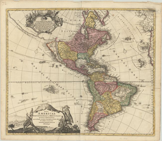
Subject: Western Hemisphere - America

Period: 1710 (circa)

Publication: Atlas Novus Terrarum Orbis Imperia...

Color: Hand Color

Size:
22.4 x 19.3 inches
56.9 x 49 cm
Download High Resolution Image
(or just click on image to launch the Zoom viewer)

This lovely early edition of Homann's map of the Americas shows California as an island on the second Sanson model. The Fretum Anian forms an entrance to a potential Northwest Passage between California and the mythical Terra Esonis Incognita, which forms a nearly continuous land bridge from North America to Asia. The Mississippi River and Great Lakes show the results of the early French Jesuit explorations. A large lake in the Southeastern United States is a remnant of Le Moyne's mythical cartography of the previous century. In South America, the Capitanias of Brazil are delineated and the Amazon and other interior features are beginning to take realistic form. The map is embellished with two fine cartouches, each with scenes of natives, Jesuits, and European merchants.

References: McLaughlin #175; Tooley (Amer) p. 129 #79; Portinaro & Knirsch #109.

Condition: B

Contemporary color on watermarked paper with a repaired 10" edge tear at right and a repaired 2" tear along the centerfold with a portion of the letter "m" of "Pacificum" in facsimile. There is light printer's ink reside and a small printer's crease to the right of the title cartouche.

Estimate: $1,100 - $1,400

Sold for: $800

Closed on 4/28/2021

Archived