Catalog Archive
Auction 182, Lot 424

"[Lot of 2] Carte Reduite de la Cote du Bresil Comprise Entre l'Ile Santa Catharina et le Cap Frio... [and] Carte Particuliere de la Cote du Bresil Partie Comprise Entre le Cap Guaratiba et l'Ile Sao Sebastiao...", Depot de la Marine
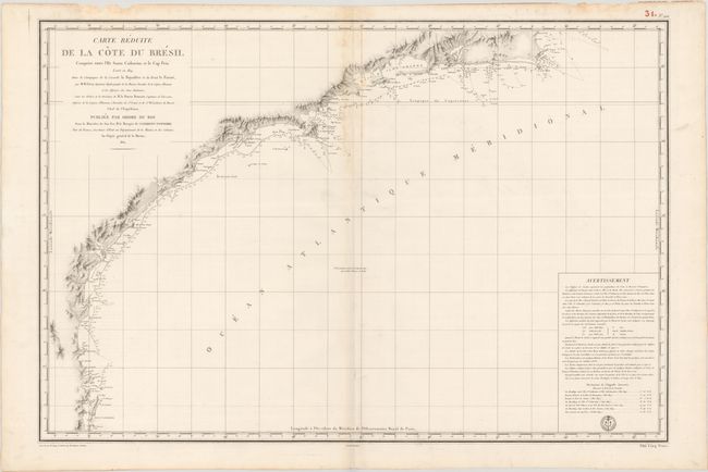
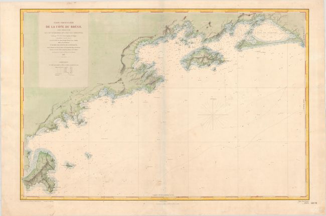
Subject: Brazil

Period: 1822-84 (dated)

Publication:

Color:

Size:
35.7 x 24 inches
90.7 x 61 cm
Download High Resolution Image
(or just click on image to launch the Zoom viewer)

These detailed navigational charts outline the coast of Brazil and are based on expeditions by M.M. Givry in 1819-20 and M.E. Mouchez in 1856-61.

A. Carte Reduite de la Cote du Bresil Comprise Entre l'Ile Santa Catharina et le Cap Frio..., dated 1822, black & white (35.7 x 24.0"). This chart covers the coast from Santa Catarina Island in the south, past Rio de Janeiro, to Cabo Frio. The seal of the Depot de la Marine is engraved at bottom right, along with the price of "Cinq Francs." Condition: A nice impression on a bright, sturdy sheet with some faint damp stains along the centerfold at top and in the top blank margin, with some small chips at top.

B. Carte Particuliere de la Cote du Bresil Partie Comprise Entre le Cap Guaratiba et l'Ile Sao Sebastiao..., dated 1884, hand color (36.5 x 24.3"). This chart extends from Ilhabela to Sepetiba Bay, the coastline between São Paulo and Rio de Janeiro. The price of "Deux Francs" is engraved at bottom right. Condition: A nice impression on a sturdy sheet with the watermark of "Service Hydrographique de la Marine P.M. Arches." There is very light toning, soiling, and some old pencil notations.

References:

Condition: B+

See description above.

Estimate: $275 - $350

Unsold

Closed on 4/28/2021

Archived