Catalog Archive
Auction 182, Lot 340

Rare Map of Richmond after Confederate Burning of the City

"Map of a Part of the City of Richmond Showing the Burnt Districts",

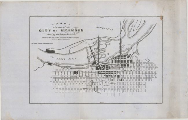
Subject: Richmond, Virginia

Period: 1865 (published)

Publication:

Color: Black & White

Size:
12.5 x 8.2 inches
31.8 x 20.8 cm
Download High Resolution Image
(or just click on image to launch the Zoom viewer)

As the Confederate soldiers retreated from Richmond in early April 1865, they were ordered to set fire to bridges, the armory, and warehouses containing their supplies. The fire spread out of control and destroyed a large part of the city, as illustrated in this map published shortly thereafter. This plan is oriented with north to the bottom of the sheet, and burned areas are marked in black. The streets, bridges, and Navy Yard are named. This map was published by William Ira Smith and drawn on stone by Charles L. Ludwig. Smith, a Unionist, became publisher of the Richmond Whig newspaper at the end of the Civil War. The April 11, 1865 issue of the Whig included an advertisement for this map: "Lithograph map of the City of Richmond showing the entire Burnt District, Embracing Navy Yard, Bridges, &c nicely gotten up." Ludwig was a native of Germany who immigrated to the United States as a young man, and was known to be working in Richmond by 1856. He did lithography work in Richmond both before and during the Civil War, including making Confederate stamps and bonds.

References: Stephenson (Civil War) #641.

Condition: B+

Printed on sturdy, grayish paper with a large Strasbourg Lily watermark and light soiling, mostly confined to the right blank margin. There are two vertical creases and some minor extraneous creasing. "North" and "South" have been added in manuscript along the neatline.

Estimate: $2,400 - $3,000

Sold for: $1,800

Closed on 4/28/2021

Archived