Catalog Archive
Auction 182, Lot 249

NO RESERVE

"[Reprint] Historical and Recreational Map of Los Angeles", Mora, Joseph Jacinto

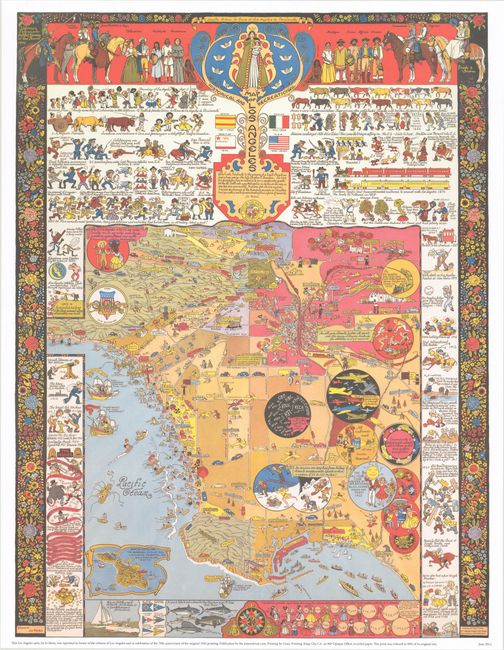
Subject: Los Angeles, California

Period: 2012 (dated)

Publication:

Color: Printed Color

Size:
22.2 x 29.2 inches
56.4 x 74.2 cm
Download High Resolution Image
(or just click on image to launch the Zoom viewer)

This is an official reprint of Mora's map of Los Angeles, issued by the Jo Mora Trust in June 2012 "in honor of the citizens of Los Angeles and in celebration of the 70th anniversary of the original 1942 printing." Only 1000 copies were printed and no additional printings have been made since. This spectacular map was one of the last that Mora created and is filled with his usual playful imagery and historical facts. The map identifies the main roads and cities within the metropolitan area, extending from Burbank in the north to Seal Beach in the south. The popular activities and notable industries are depicted within the map and in large round insets. The map is surrounded by an illustrated history of Los Angeles from its founding in 1781 to the 1938 flood. The borders include additional information, including the various types of people who inhabited the city during its history wearing their traditional costumes, a visual representation of the population growth, and a decorative surround of flowers and birds.

Joseph ("Jo") Jacinto Mora was born in Uruguay in 1876 and moved the following year with his family to the eastern United States. He showed an early aptitude for the arts and began illustrating for newspapers and children's books in his twenties. Mora was fascinated with the American West, and after working on cattle ranches in Texas and Mexico as a young adult, he moved permanently out west in 1903. He spent his time learning about old Spanish vaqueros, American cowboys, and the Hopi and Navajo tribes, subjects which became lifelong passions and the focus of much of his work. His paintings and photographs of the Hopi were memorialized into a traveling exhibit for the Smithsonian Institution in 1979.

Mora was an artist with many talents, including drawing, painting, illustration, sculpture, photography, writing, and mapmaking. His artistic skills were perhaps unsurprising, as his father was a noted sculptor, and Jo Mora on occasion helped his father on sculpting commissions, including the facade of the Native Sons of the Golden West Building in San Francisco. His foray into mapmaking began later in his career while he was residing in Pebble Beach, California, where he would spend the last 27 years of his life. Mora's first map was of the Monterey peninsula, entitled California's Playground, and was commissioned by the Del Monte Hotel to commemorate the hotel's grand reopening in 1926. The map combined historical facts with whimsical illustrations, cartographic points of interest, cartoonish figures, and witty notations. And thus was born Mora's unique style that is common on all of his "cartes," a term that he used for his cartographic works. Although Mora only created about a dozen maps in his career, Stephen J. Hornsby contends that "His maps formed the most important collection of pictorial cartography done by any artist of one particular region of the United States" (Hornsby, p. 29).

Provenance: Jo Mora Trust.

References: Hornsby (Picturing America) pp. 28-31; Rumsey #10020.

Condition: A+

Like new.

Estimate: $40 - $50

Sold for: $55

Closed on 4/28/2021

Archived