Catalog Archive
Auction 182, Lot 183

Very Rare First State of De Fer's Important Map of the Lower Mississippi Valley

"La Riviere de Missisipi, et ses Environs, dans l'Amerique Septentrionale...", Fer, Nicolas de

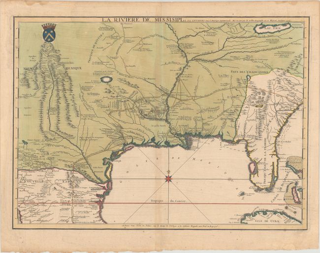
Subject: Colonial Southern United States

Period: 1715 (dated)

Publication:

Color: Hand Color

Size:
25.3 x 18.3 inches
64.3 x 46.5 cm
Download High Resolution Image
(or just click on image to launch the Zoom viewer)

This exceptionally rare map is based upon an unpublished manuscript map of the region by Guillaume Delisle entitled Carte des Environs du Missisipi. Produced in 1701, the manuscript map was compiled based upon several sources including previous maps from La Salle, several Spanish expeditions in the region, and most notably the recent discoveries of Pierre Le Moyne d'Iberville. According to Paul Cohen in Mapping the West the manuscript "revealed for the first time the importance of the Missouri River and gave the most accurate delineation of the Mississippi Valley up to that time." It appears that only a very limited number of De Fer's map were printed, and the map's rarity is compounded by the fact that Delisle himself chose not to make a printed version of the manuscript map.

Cartographically, the map covers a large section of the United States, and its geographic footprint follows closely to that of Delisle's map of 1718 but does not include all the Great Lakes. Along the southeast coast, De Fer closely follows Sanson's 1696 map of Carolina. To the west, De Fer borrows from Delisle's 1703 Carte du Mexique et de la Floride... with the depictions of Spanish and Indian settlements in Texas and New Mexico. The map is important for its depiction of the numerous Indian villages (identified by tiny gilt dots) along the Little Tennessee River, Red River, and upper Rio Grande and depicts the trading path that "the English of Carolina take to visit the Chickasaws." The map identifies La Salle's route from Matagorda Bay to the north as well as a Spanish road to the south. Political geography is also emphasized here with French claims extending to the Appalachians and encroaching on English settlements. The map is embellished by a French crown and a compass rose with fleur-de-lis in the Gulf of Mexico. A second state of this map was issued in 1718, the same year that Delisle published his more widely-known Carte de la Louisiane et du Cours du Mississipi based upon a later manuscript map. The second state, entitled Partie Meridionale de la Riviere de Missisipi, et ses Environs, dans l'Amerique Septentrionale, includes new information on French development in the interior, locates additional Indian tribes, and features some decorative elements as well.

This 1715 map is exceedingly rare with only one dealer listing in the last 40 years and no past auction records. There are four institutional examples listed on OCLC, and only one example in the United States (University of Texas - Arlington). The 1718 second state, while still scarce, is more frequently encountered on the market.

References: Cohen (Mapping the West) pp. 48-51; cf. Cumming (SE) #131 & #169; cf. Pastoureau FER II-C #94.

Condition: B+

Full contemporary color with gilt highlights on a watermarked sheet with light toning along the centerfold and some minor foxing. There are a couple of small dampstains along the top edge of the sheet, and a small edge tear that just enters the border at top right.

Estimate: $20,000 - $25,000

Sold for: $30,500

Closed on 4/28/2021

Archived