Catalog Archive
Auction 181, Lot 702

Rare English Edition of Cook's Landmark Map of New Zealand

"Chart of New-Zealand, Explored in 1769 and 1770", Cook, James (Capt.)

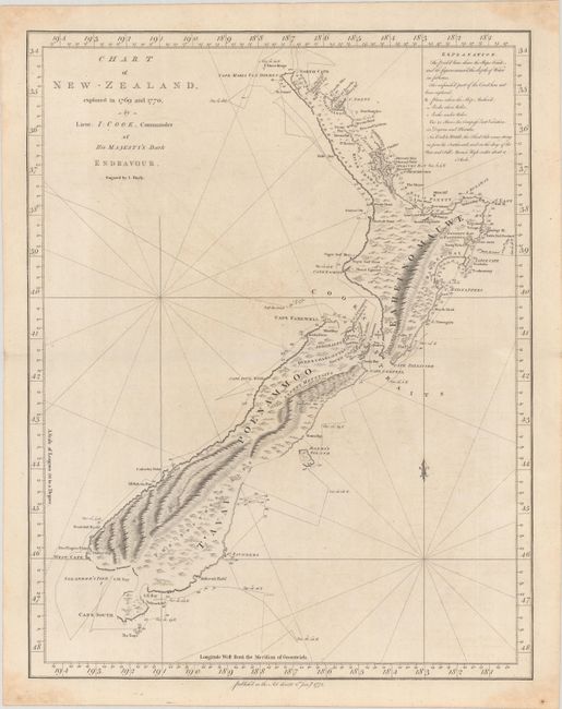
Subject: New Zealand

Period: 1772 (dated)

Publication: An Account of the Voyages…in the Southern Hemisphere…

Color: Black & White

Size:
15 x 19.3 inches
38.1 x 49 cm
Download High Resolution Image
(or just click on image to launch the Zoom viewer)

Captain James Cook (1728-1779) is best known for his three voyages to the Pacific (1768-71; 1772-75; and 1776-79). His discoveries radically changed the western understanding of the world in the late 18th century. He was the first to circumnavigate and chart New Zealand and provided the earliest European accounts of exploration along the eastern coast of Australia and the Hawaiian Islands. On February 14th, 1779, he was killed on Hawaii after attempting to kidnap the chief of the island.

Many contemporary accounts of Cook’s voyages, including charts and engravings, appeared in the late 18th century. The first official account of Cook’s first voyage was published in 1773 by John Hawkesworth in Volumes II and III of An Account of the Voyages Undertaken by the Order of His Present Majesty for Making Discoveries in the Southern Hemisphere... William Strahan and Thomas Cadell published the first official accounts of the second and third voyages in 1777 and 1784. Accounts of his exploration were subsequently translated into French, German, and Dutch.

This is the first edition of one the most important maps in New Zealand's history and the first complete map of the two islands' coastlines. The English edition is considerably less common on the market than its French counterpart. The chart was made during Cook's first voyage and shows the track of the Endeavour with dates and soundings. The interior reflects the mountainous topography. This chart appeared in Volume II of John Hawkesworth's An Account of the Voyages Undertaken by the Order of His Present Majesty for Making Discoveries in the Southern Hemisphere..., which was the very first official account of Cook's voyages to be published. Engraved by John Bayly.

Capt. James Cook sailed from England in 1768 on his ship the Endeavour on his first round-the-world voyage visiting islands in the Pacific before sighting New Zealand's north & south islands and the strait that divides them, which he named Cook's Strait. Between 1769-1770 Cook sailed around both islands, proving that they were independent of the Great Southern Continent, which was what navigators had believed since Abel Tasman discovered the land mass in 1642. This finely engraved map was taken from a sketch brought back to London by Cook in 1771, which was published in English in London by Cadell & Strahan in 1773, and in French in Paris in 1774.

References: Shirley (BL Atlases) G.HAWK-1a #22; Tooley (Australia) p. 45 #322.

Condition: B+

Issued folding on watermarked paper with faint scattered foxing and minor offsetting. There is some light dampstaining confined to the blank margins.

Estimate: $2,000 - $2,300

Sold for: $3,750

Closed on 2/10/2021

Archived