Catalog Archive
Auction 181, Lot 60

"L'Amerique, Meridionale et Septentrionale Dressee Selon les Dernieres Relations et Suivant les Nouvelles Decouvertes...", Fer, Nicolas de

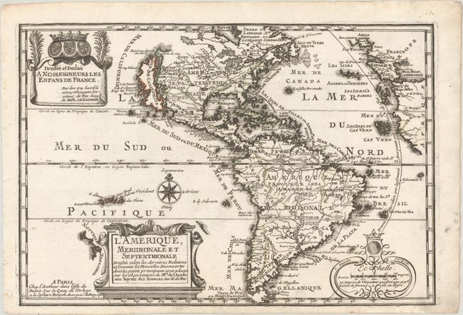
Subject: Western Hemisphere - America

Period: 1700 (dated)

Publication: L'Atlas Curieux ou le Monde...

Color: Hand Color

Size:
13.2 x 8.9 inches
33.5 x 22.6 cm
Download High Resolution Image
(or just click on image to launch the Zoom viewer)

This is the first state of this charming map of the Americas. It is a reduced derivative of De Fer's classical wall map of 1698 with information gathered from the archives of the Academie Royale des Sciences. The island of California covers the entire west coast of North America north of the Tropic of Cancer with two large imaginary islands off shore. One of the prominent features in northern Mexico is Les Mine de S. Iean et de Ste. Barbe, the legendary Santa Barbara mines of the Chihuahua-Durango region. There are several large spurious lakes on both continents. A partial coastline of New Zealand appears beside the title cartouche. The map is richly decorated with three cartouches and a compass rose.

This lot includes a page of accompanying French text describing America.

References: Burden #759; McLaughlin #135, Pastoureau, FER I A #5; Tooley (Amer) #61, p. 126.

Condition: A

A nice impression with some minor soiling that is mostly confined to the margins.

Estimate: $600 - $750

Sold for: $425

Closed on 2/10/2021

Archived