Catalog Archive
Auction 181, Lot 438

"Pascaert vande Noort-Zee om Achter Yrland en Schotland om te Seylen / Mare Germanicum ac Tractus Maritimus Retro Hiberniam et Scotiam", Ottens, Reiner and Joshua
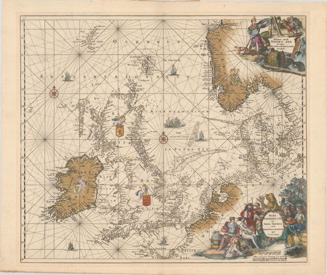
Subject: North Sea

Period: 1740 (circa)

Publication:

Color: Hand Color

Size:
22.4 x 19.3 inches
56.9 x 49 cm
Download High Resolution Image
(or just click on image to launch the Zoom viewer)

This beautiful sea chart of the North Sea includes the British Isles, the Faroe Islands, and the stretch of coastline extending from Norway south to Normandy. It includes two compass roses and is crisscrossed by rhumb lines. The seas are filled with sailing ships and a naval battle, and putti hold aloft the coats of arms of Ireland, Scotland, England, and Norway. Soundings appear throughout. There is a Dutch title cartouche at top right that features Athena with a fox and a bear and a logging scene. An additional Latin title cartouche at bottom right shows various allegorical figures including Neptune, Urania, and the States Lion with his sword and arrows. This chart was originally made and published by Frederick de Wit. The plate was acquired by the Ottens brothers after the death of De Wit's son in 1706. Following the general custom of the time, the Ottens erased the De Wit imprint, replacing it with their own.

References:

Condition: A

A sharp impression with contemporary color in the map and later color in the decorative elements. There are a few faint spots,a printer's crease at bottom right, and a tiny hole in "Watte Bank" that is only visible when held to light. There is minor toning in the blank margins and remnants of hinge tape on verso.

Estimate: $1,400 - $1,700

Sold for: $1,000

Closed on 2/10/2021

Archived