Catalog Archive
Auction 181, Lot 308

A Rare Commercial Map Capitalizing on Interest in the American Southwest

"Map of Mexico, Texas, Old and New California, and Yucatan. Showing the Principal Cities and Towns, Travelling Routes &c.",

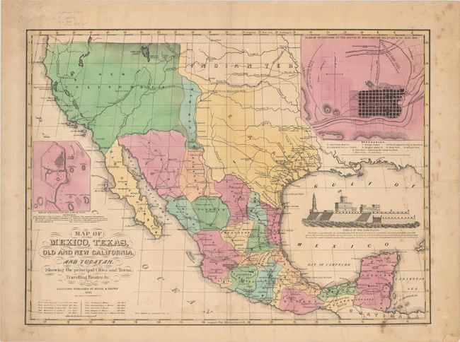
Subject: Southwestern United States & Mexico

Period: 1847 (dated)

Publication:

Color: Hand Color

Size:
23.6 x 17.3 inches
59.9 x 43.9 cm
Download High Resolution Image
(or just click on image to launch the Zoom viewer)

This rare map of the evolving Southwest was lithographed by E.B. & E.C. Kellogg and published by House & Brown in Hartford, Connecticut. It shows a large Texas with a stovepipe extending well into present-day Colorado and Santa Fe is within its borders. A sliver of New Mexico is wedged between Texas and New California with the Mexican provinces delineated and colored. Wagon roads, trails, and battle sites near Goliad, Ft. Brown and Monterey are depicted. Includes insets of the "Plan of Operations at the Battle of Monterey", "Map of Vera Cruz and San Juan de Ulloa", and a view of Castle of San Juan D'Ulloa. House & Brown issued this map to capitalize on interest in Disturnell's treaty map as well as Mitchell's Map of Mexico, Including Yucatan & Upper California, though the finished product was mediocre at best. Wheat states that "there are a few hints that Fremont's 1845 map was known to whoever drew this map, and some lines labeled 'Fremont's Route' are included, but for areas now in the United States the map is wholly unsatisfactory."

A rare map with only one sale record in the last 30 years.

References: Wheat (TMW) #545; Day #398.

Condition: B+

There is light scattered foxing mostly along the right border and an edge tear at right that extends 3" into the image that has been closed on verso with old paper. A short centerfold separation at bottom and two short edge tears have been closed on verso with archival tape.

Estimate: $2,750 - $3,500

Sold for: $1,700

Closed on 2/10/2021

Archived