Catalog Archive
Auction 180, Lot 340

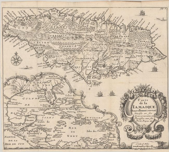
"Carte de la Iamaique Nouvellement Reveue, Divisee en ses Gouvernemens, ou Paroisses, avec ses Ports, Bayes, Etc.", Blome, Richard

Subject: Jamaica, Gulf of Mexico & Caribbean

Period: 1715 (published)

Publication: Description des Isles et Terres que l'Angleterre Possede en Amerique

Color: Black & White

Size:
11.4 x 9.9 inches
29 x 25.1 cm
Download High Resolution Image
(or just click on image to launch the Zoom viewer)

This uncommon and elegantly engraved map is the French version of Blome's A New & Exact Mapp of ye Isle of Iamaica... (1672) with French title and nomenclature and an altered title cartouche. Its depiction of Jamaica is derived from John Ogilby's 1671 map of the island. It divides the island into 13 parishes and depicts St. Iago (Spanish Town) as a small square grid. Numerous place names appear along the coastline, and there are soundings and anchorages offshore. The sea surrounding Jamaica is filled with ships, sea creatures, and a compass rose capped with a fleur-de-lis. At bottom left, there is a large inset showing the Gulf of Mexico and Caribbean, with the colonies of Florida, Carolina, and Virginia identified. A decorative title cartouche and distance scale adorn the bottom right corner. This example appeared in the second French edition of Richard Blome's The Present State Of His Majesties Isles and Territories in America, a guidebook to British colonial interests in North America that was first published in 1687.

References: Burden #642; Kapp (MCC-42) #19.

Condition: B+

A crisp impression issued folding on watermarked paper that has been trimmed to the border at right.

Estimate: $350 - $425

Sold for: $325

Closed on 11/18/2020

Archived