Catalog Archive
Auction 180, Lot 282

"A Pictorial Map of That Portion of New York City Known as Manhattan Also Showing Parts of the Bronx",

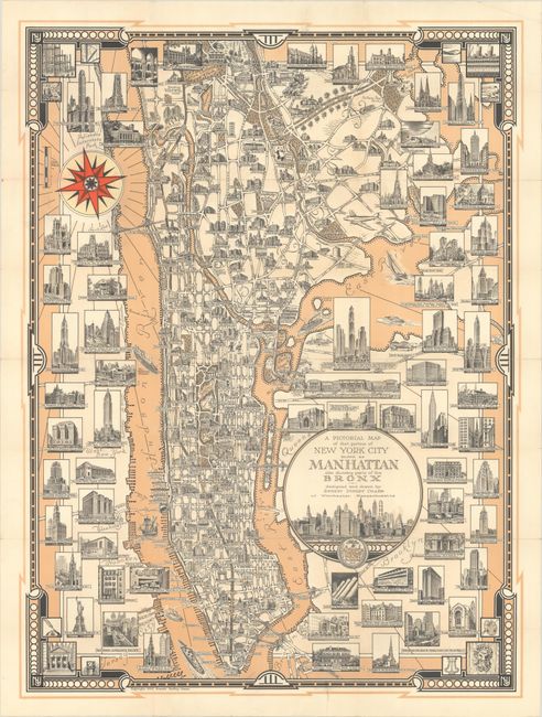
Subject: New York City, New York

Period: 1939 (dated)

Publication:

Color: Printed Color

Size:
20.5 x 27.5 inches
52.1 x 69.9 cm
Download High Resolution Image
(or just click on image to launch the Zoom viewer)

This pictorial map by Ernest Dudley Chase focuses on the superb architecture in Manhattan and part of the Bronx. The bird's-eye plan of the city labels all major streets, bridges, and buildings, which fill the spaces between the streets. Each building is shown in three-dimensional perspective to help showcase its architecture. The surrounding areas, such as Brooklyn, Queens and Hoboken are overlaid with dozens of additional images of buildings and street scenes, including the Statue of Liberty, the Empire State Building, the Museum of Modern Art, Grand Central Station, Times Square, Park Avenue, Rockefeller Center, and the Holland Tunnel. The theater district on Broadway is identified with a "Bright Lights" sign. A few New Yorkers are also depicted within city and various types of vessels are shown in the Hudson and East Rivers. The title cartouche features a lovely skyline and the seal of New York City. The map is surrounded by an art deco border. Designed and drawn by Ernest Dudley Chase, who was a leader in pictorial mapmaking during the middle 20th century. An outstanding map that exemplifies the sophistication and charm of New York City.

References: Rumsey #11161.

Condition: A

Issued folding and now flattened and backed in thin, archival tissue to repairs some minor fold separations and three short edge tears at top and bottom.

Estimate: $550 - $700

Sold for: $750

Closed on 11/18/2020

Archived