Catalog Archive
Auction 180, Lot 109

Features the Short-Lived Franklinia and Morgania

"Map of the United States, Canada the River St. Lawrence, the Lakes &c.", Phillips, Richard (Sir)

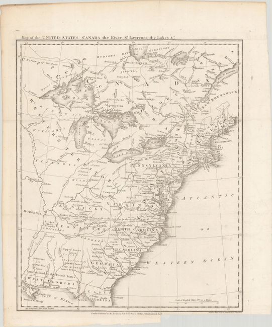
Subject: Eastern United States & Canada, Franklin

Period: 1801 (dated)

Publication: British Military Library, or Journal

Color: Black & White

Size:
13.4 x 16 inches
34 x 40.6 cm
Download High Resolution Image
(or just click on image to launch the Zoom viewer)

This great map of the fledgling nation includes numerous areas of interest including the proposed state of Franklinia and the Spanish sponsored Morgania colony. In New England, Maine is shown with a truncated northern boundary, reflecting the British view of the border dispute. Georgia's western boundary is the Mississippi River. Florida, at the time a Spanish territory, is divided into East and West, with the notation "Land Claimed by the United States" on the northern boundary on the 31st parallel. A note above North Carolina and Tennessee states "Northern Boundary of North Carolina as far as the South Sea." The proposed state of Franklinia is located in eastern Tennassee. In 1785 settlers in present-day western North Carolina and eastern Tennessee organized a state government to be named in honor of Benjamin Franklin. Congress turned down their appeal but the fledgling state maintained a legislature and governor until 1788. To the west of the Mississippi is Morgania. This region was named after George Morgan, a land speculator, who attempted to create a new colony in the then Spanish controlled Louisiana Territory near New Madrid (Morgan gave up this endeavor a few years later). Engraved by Smith & Jones.

References: Dotson & Baker (OWA) #14a.1; Baynton-Williams #11i.

Condition: A

Issued folding on a bright sheet with a binding trim in the bottom margin and a short associated binding tear that has been closed with archival materials on verso.

Estimate: $1,400 - $1,700

Sold for: $1,000

Closed on 11/18/2020

Archived