Catalog Archive
Auction 179, Lot 770

"Erythraei sive Rubri Maris Periplus, olim ab Arriano Descriptus, nunc Vero ab Abrah. Ortelio ex Eodem Delineatus", Ortelius, Abraham

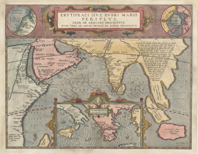
Subject: Southern Asia, Arabia & Eastern Africa

Period: 1597 (dated)

Publication: Theatrum Geographiae Veteris…

Color: Hand Color

Size:
18.3 x 14.1 inches
46.5 x 35.8 cm
Download High Resolution Image
(or just click on image to launch the Zoom viewer)

This map from Ortelius' series of historical maps covers from Egypt to Indonesia as far as Java with a large inset of the eastern Mediterranean Sea centered on Greece. In the upper right is an inset of the North Pole (Hyperborei) included by Ortelius to remind his readers that despite recent attempts, a passage to the Far East via the North Pole had not yet been found. To balance the composition Ortelius included an inset of Annonis Periplus in the upper left corner. This map represents the Northwest coast of Africa showing part of the explorations of the ancient King Hanno from Carthogo, who legend says was the first to sail around the continent of Africa to reach the Arabian sea. A very graphic and unusual map with a fully stippled sea. Blank verso. Published in Petrus Bertius' Theatrum Geographiae Veteris…, which included maps by Mercator, Ortelius, and newly engraved maps by Pieter van den Keere.

References: Van den Broecke #224.

Condition: B+

A nice impression on a bright sheet with a professionally repaired centerfold separation that enters 1" into image at bottom. The map has been trimmed to the neatline and professionally remargined with a portion of the neatline replaced in facsimile.

Estimate: $700 - $850

Sold for: $350

Closed on 9/16/2020

Archived