Catalog Archive
Auction 179, Lot 335

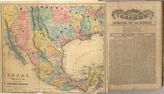
Early Map Depicting the Republic of Texas

"[Map in Book] Texas, Mexico, and Part of the United States. Compiled from the Latest and Best Authorities [bound in] Atkinson's Casket Gems of Literature, Wit and Sentiment", Yeager, James

Subject: Southwestern United States & Mexico, Texas

Period: 1836 (published)

Publication:

Color: Hand Color

Size:
10.1 x 8.6 inches
25.7 x 21.8 cm
Download High Resolution Image
(or just click on image to launch the Zoom viewer)

This rare map is one of the earliest maps to delineate the nascent Republic of Texas, here with Austin's and Dewitt's Colonies distinguished in pink. The southwestern border between Texas and Mexico follows the Nueces River which was later extended to the Rio Grande. Locates numerous Indian regions including the Whaco in Texas, Moqui, Navaho, several Apache tribes including the Mescalaros in Chihuahua, and many more. In Texas the settlements of San Felipe, Matamoras, Brazaria and Victoria are located. The map is still bound into the 656 page Atkinson's Casket Gems of Literature, Wit and Sentiment, which includes 12 monthly publications bound into a single volume. Octavo, hardbound in quarter calf with tips over marbled boards.

References: Sabin #11335.

Condition: B

The map is trimmed to the border at bottom and there is a 1" binding trim at right that has been closed on verso with tissue. Text has moderate scattered foxing that is more prominent in the first third of the volume. Covers have moderate shelf wear with previous owner's label on front cover and bookplate on the front pastedown.

Estimate: $1,100 - $1,400

Sold for: $800

Closed on 9/16/2020

Archived