Catalog Archive
Auction 179, Lot 293

"A Map of the Tennassee Government from the Latest Surveys", Payne, John
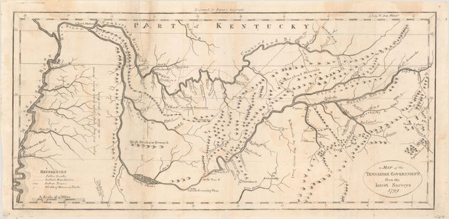
Subject: Tennessee

Period: 1799 (dated)

Publication: John Payne's New and Complete Universal Geography

Color: Black & White

Size:
15.1 x 7.1 inches
38.4 x 18 cm
Download High Resolution Image
(or just click on image to launch the Zoom viewer)

This is a very early depiction of Tennessee based on maps by Carey and Reid. The map details the topography and notes the early Kentucky Road as it winds down to the Holsten River, where Ross's Ironworks are located. The map also traces the Mississippi, Tennessee, and Cumberland Rivers, and extends as far south as the northern portion of what would become Alabama. The early settlements of Nashville, Knoxville and Clerksville are shown, and Fort Massac is located on the Ohio River.

References: Wheat & Brun #657.

Condition: B

Issued folding and now flat with some faint dampstains. There are repairs to several fold separations along the left fold and to a small chip at top (0.25 x 1.5") with the letter "A" in facsimile.

Estimate: $600 - $750

Sold for: $300

Closed on 9/16/2020

Archived