Catalog Archive
Auction 179, Lot 238

"Topographical Map of the Breckenridge Gold Belt Summit County Colorado",

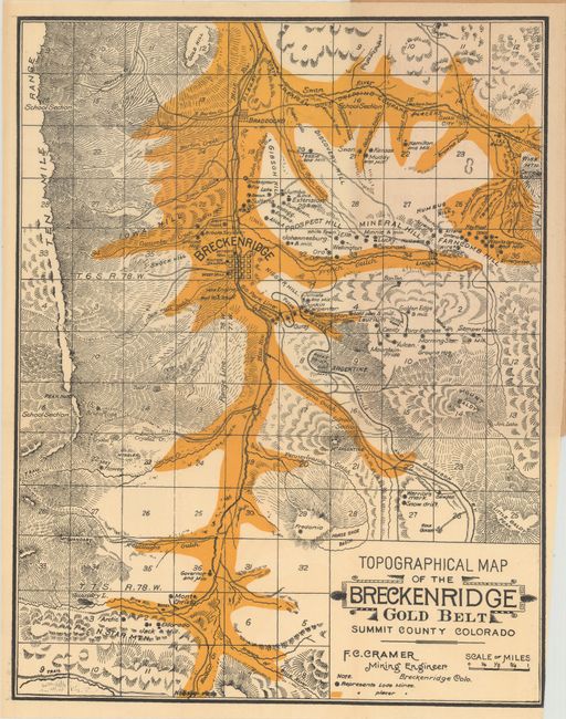
Subject: Breckenridge, Colorado

Period: 1890 (circa)

Publication:

Color: Printed Color

Size:
10.4 x 13.5 inches
26.4 x 34.3 cm
Download High Resolution Image
(or just click on image to launch the Zoom viewer)

This map of the vicinity of Breckenridge was drawn by F.C. Cramer, Mining Engineer, and issued by the passenger department of the Denver, Leadville & Gunnison Railway Company. It depicts the valuable placer mines in bright yellow primarily along the Blue and Swan rivers and also locates numerous lode mines. This region was part of the Colorado Gold Rush of the 1860s, and gold continued to be mined with success through the end of the 19th century. Accompanying the folding map is an additional full page "Map of Colorado" (7.4 x 8.0") showing the lines of the Union Pacific, Denver & Gulf as well as the Denver, Leadville & Gunnison Railroad. The 16 pages of text accompanying the maps entices both investors and prospectors to the area. Folds into tan paper wrappers (4.2 x 8.7"). No past sales records and only 1 institutional example located on OCLC (Denver Public Library).

References:

Condition: A

The folding map is fine with no tears or separations. Text has a hint of light toning, and the wrappers are lightly soiled and detached (the map is still attached to the front wrapper).

Estimate: $160 - $190

Sold for: $1,400

Closed on 9/16/2020

Archived