Catalog Archive
Auction 179, Lot 18

"Planiglobii Terrestris Mappa Universalis Utrumq Hemisphaerium Orient et Occidentale Repraesentans... / Mappe-Monde qui Represente les Deux Hemispheres Savoir Celui de l'Orient et Celui de l'Occident...", Haas/Homann Heirs
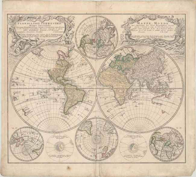
Subject: World

Period: 1746 (dated)

Publication:

Color: Hand Color

Size:
21.7 x 18.3 inches
55.1 x 46.5 cm
Download High Resolution Image
(or just click on image to launch the Zoom viewer)

This handsome double-hemisphere world map was drawn by Georg Moritz Lowitz, based on the work of Johann Mathias Haas. It includes four polar spheres, each in a different projection, and two interesting diagrams depicting the earth, as it would be seen from space. North America is still blank above California and Hudson Bay is open-ended in the northwest corner. The large, mythical Xarayes Lake appears in the center of South America. In the South Pacific there are partial coastlines of New Zealand, Australia, and Tasmania. Two very large, decorative cartouches contain the titles, one in Latin, the other French. The Latin cartouche features mythical sea creatures and wind heads while the other is surrounded by fruit and animals representing the bounty of the earth along with four headdresses representing the four continents.

References:

Condition: B+

On watermarked paper with light scattered foxing, minor soiling, and some small tears around the centerfold at bottom that have been closed on verso with archival materials. There are some very faint manuscript notations in pencil.

Estimate: $1,000 - $1,300

Sold for: $750

Closed on 9/16/2020

Archived